| ch. 3, pp. 19 - 21 |
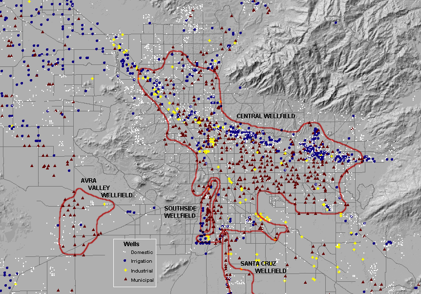
Thus, the broad pattern of steady, region-wide groundwater level declines is seen at a greater level of detail to be a more complex pattern of rising and dropping groundwater levels, influenced by local water uses and recharge, and by the impacts of wet and dry years. IMPACTS OF EXCESSIVE GROUNDWATER PUMPING There are several major impacts associated with continued groundwater pumping in excess of the rate of natural recharge. The most far-reaching and potentially destructive is land subsidence and earth fissures. Other impacts include increasing costs of pumping groundwater and generally decreasing quality of groundwater pumped from greater depths. Subsidence
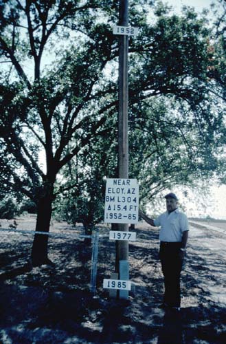
A consequence of water level declines is land subsidence. According to an Arizona Geological Survey publication �subsidence is the downward movement or sinking of the earth�s surface caused by removal of underlying support.� In Arizona, subsidence usually results from excessive groundwater pumping. As water is pumped from an aquifer, the water occupying spaces between rock particles is removed, and the water level or water table drops. Without the buoyancy of the groundwater, the particles become more tightly packed together; i.e., the particles compact and consolidate. Continued pumping of groundwater without adequate recharge causes sediments to become increasingly compressed, and the land surface to settle or subside. (See Figure 3-4.) In most cases, subsidence resulting from groundwater pumping occurs at about the same rate over large areas and can be difficult to detect. However, abrupt changes in conditions below the land surface can cause the rate of subsidence to vary considerably over a short distance. This �differential subsidence� is more likely to cause damage to houses, commercial buildings, or infrastructure such as water and sewer lines or roads. A related phenomenon, an earth fissure is a visible, and sometimes even spectacular manifestation of land subsidence. Fissures usually are noticed first as land cracks or crevices, a break in the earth�s surface. They can then grow considerably as water erodes the fissured area. Gullies or trenches may be up to 50 feet deep and 10 feet wide, with the fissure extending hundreds of feet below the surface. The fissure may range in length from a few hundred feet to over eight miles. �El Grande� fissure system is ten miles long and is located in the Picacho Basin, northwest of Tucson. The average length of a fissure is measured in hundreds of feet. In the Tucson area fissuring has occurred west of the Tucson Mountains in Avra Valley.
Urban areas are especially vulnerable to the damaging effects of subsidence. Cities are dense areas of population, with large numbers of buildings and facilities. Also within urban areas are the varied projects and structures � bridges, highways, electric power lines, underground pipes, etc. � that make up the urban infrastructure. Railroads, earthen dams, wastewater treatment facilities and canals also are prone to damages from subsidence. Sewer lines, laid at precise gradients, can have their slopes reduced or even reversed, with serious consequences. Any structure built across the path of a fissure likely will suffer serious damage. Careful and expensive construction procedures were worked out to protect the CAP canal from subsidence damage in certain areas. Despite these precautions, the canal was damaged by an earth fissure in Pima County in 1988. The U.S. Geological Survey (USGS) reports that since 1940 groundwater levels in Central Arizona have dropped over 220 feet, with Central Tucson subsiding at least one foot since 1950. Meanwhile the rate of subsidence in the area is increasing. Satellite images show that sections of central Tucson are sinking at the rate of 2 centimeters or 0.8 inches per year. USGS monitors water level changes and subsidence at 19 southern Arizona sites. Some USGS sites are in Tucson.
|