 |
Most water issues have to do with either water supply or water quality. In more personal terms these issues have to do with our need for an adequate supply of good quality water. This chapter looks at Tucson’s water supplies and our need for sufficient water resources to support our growing community. Present resources are described; methods to make present supplies go further are discussed; and possible strategies for bringing new water supplies into the basin are described. Chapter 5 discusses how we use water, and Chapter 6 discusses water quality.
|
TUCSON’S WATER SUPPLIES
For many centuries, people who lived in the Tucson area used less water than was available from snow in the mountains or rain. Precipitation or runoff and a high water table could be counted on to maintain the flow of the river. Those days are long gone. Today, virtually all the water we use originates as stored groundwater. This groundwater also is naturally replenished, partly by rainwater and snowmelt from the mountains and partly from return flow after various human uses, such as irrigation and wastewater effluent discharges. The surface water that replenishes the aquifer, however, is not sufficient to ensure a sustainable supply of groundwater in the face of current levels of demand. The stored groundwater supplies have not been substantially renewed for many years. In fact, our excessive pumping of groundwater is the reason little or no surface flow remains in Tucson rivers. New sources of water, such as CAP water and effluent, offer the possibility that we can stop or reduce
the mining of our
stored groundwater.
NON-RENEWABLE SUPPLIES
Stored Groundwater
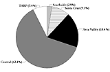 |
| Figure 3-1 Contribution of Tucson Water wellfields to total groundwater supplySource: Tucson Water |
Two main aquifers supply water to the Tucson area, one located in the Tucson Basin and the other in the Avra Valley Basin. In 1940, when Tucson began to increase its groundwater pumping, these aquifers held approximately 70 million acre-feet of groundwater at depths less than 1,200 feet below the surface. Since 1940, approximately 6 to 8 million acre-feet, or 9 to 11 percent of the total has been withdrawn.
WHAT IS GROUNDWATER?
Groundwater is water that fills spaces under ground, between grains of sand or rock or in subterranean cracks. The area where groundwater occurs is the “aquifer.” The top level of the aquifer saturated with groundwater is the “water table.” The most productive aquifers consist of water stored in sand and gravel. These areas are typical of ancient floodplains (alluvium) where water, rocks and sand were deposited at about the same time. Water and soils flowing from mountains over long periods of time created some of Tucson’s most productive aquifers.
Openings between the subterranean storage areas must be interconnected for water to flow freely. Over the years, water moves slowly downward to the aquifer and also spreads out, moving generally northwest in the Santa Cruz Valley. At some point, the water will reach solid rock or a layer of clay. When such an impermeable layer is near the surface, water may occur as surface flow or springs. If the water table is relatively close to the surface, rivers can flow. Excessive pumping from aquifers causes the water table to recede, and surface flow is no longer possible except during rainy periods. Another impact of pumping is that grains of sand or rock compact as water is withdrawn. Percolating water then is much less likely to refill the spaces, especially at greater depths. Tucson’s water table has significantly dropped throughout most of the region.
|
|
|
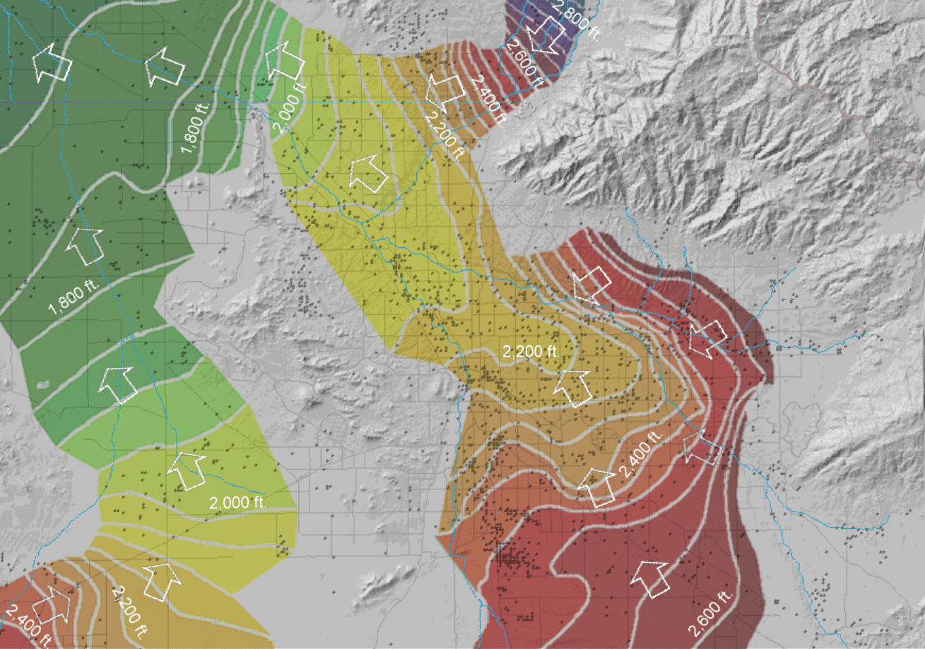
| Figure 3-2 Elevation of water table and direction of groundwater flow.Source: Arizona Department of Water Resources, Water Resources Reasearch Center. |
A wellfield is a group of wells used by a water provider in an area where the subsurface geology is suitable for pumping. The wells may not be located close together but might still be referred to as a wellfield for administrative purposes. Tucson Water currently operates four major wellfields – Central, Southside, Santa Cruz and Avra Valley. A fifth wellfield is being developed further north in the Avra Valley, to recover recharged water from the Central Avra Valley Storage and Recovery Project. Tucson Water delivered approximately 114,000 acre-feet of groundwater in 1996. Figure 3-1 shows how much each wellfield contributes to total pumping.
The distance from land surface to the water table is termed “depth to water.” The present depth to water in the Tucson area ranges from less than 50 feet to more than 700 feet. In certain parts of the Tucson Mountains, it is as much as 900 feet. Depth to water is greatest in the foothills of mountain fronts and shallowest in the Altar, Brawley and Cañada del Oro washes and near Rillito Creek and the Tanque Verde Wash. In the Tucson area groundwater generally flows slowly to the north and northwest, at an average rate of only about several hundred feet per year, or a foot or two per day. (See Figure 3-2.)
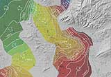
The figure on the inside cover of this document shows changes in groundwater levels since 1940. Between the 1940s and 1995, groundwater levels declined over 150 feet northwest of the Green Valley/Sahuarita area as a result of pumping by copper mines. Water levels declined more than 200 feet in parts of the Central Wellfield and over 100 feet in the Southside Wellfield due to pumping by the City of Tucson. Current declines in the Central Wellfield are averaging up to four to five feet per year.
Water levels have declined over 150 feet in the southern Avra Valley. The City of Tucson retired farmland in this area, and water levels have rebounded at some locations. Water levels have continued to decline in other parts of southern Avra Valley, in areas where the Tucson Water is pumping water for municipal use.
|
|