| ch. 3, pp. 21 - 23 |
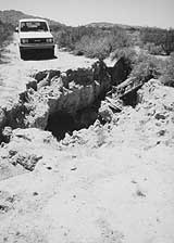
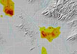
NPA Satellite Mapping is a company that uses satellite images taken over a period of years to plot subsidence. Satellite imagery coupled with a technique called interferometry determines the subsidence rate. This procedure was applied to identify a large subsidence area in central Tucson, centered at the intersection of East Speedway and Country Club Road. This marks the spot of the greatest subsidence activity in the Tucson area. USGS models predict levels of subsidence likely to occur in Tucson wellfields. Assuming that groundwater pumping and natural recharge rates continue at 1986 levels through 2025, and based on other assumptions about the aquifer material being compacted, USGS models indicate that maximum subsidence could range from 1.2 to 12 feet in the Central Wellfield by the year 2025. (See Figure 3-6.) Under the same assumptions, subsidence in the Santa Cruz Wellfield could reach up to 4 feet by the year 2025. For northern Avra Valley, maximum subsidence potential is estimated to range from 0.9 to 14.7 feet by the year 2025, assuming that pumping levels and natural recharge rates continue at 1970s levels. If subsidence approaches the maximum level projected for the year 2025 in the Central Wellfield, the risk of differential subsidence is significant, especially near downtown Tucson. Subsidence can be halted by ceasing or limiting groundwater withdrawal in an area. Also, under the right conditions, overdraft may be reduced through artificial recharge, thus slowly decreasing the danger of further subsidence. In most cases, subsidence is termed inelastic because the sinking of the ground is permanent, and recharge would not reverse the process. Well-injection recharge is likely to be more effective than other types of recharge at ensuring that water is recharged close to the compacting layers. Surface water recharge projects may be effective at restoring the water table. In most cases, however, once subsidence occurs, the water storage capacity of the aquifer is permanently reduced. In some cases, recharge projects may even worsen subsidence, as the weight of the water applied at the surface compacts the underlying aquifer materials even more. Increased Pumping Cost In those areas with the most pumping, water level declines may lead to lower productivity because as the water is pumped from greater depths, the aquifer materials become more compacted and hold less water. For example, well yields in the Santa Cruz and Southside Wellfields have decreased over the years. Average yield for wells in the Santa Cruz Wellfield in 1992 was less than a third of what it was in 1958. Average yield in the Southside Wellfield in 1992 was about half of what it was in the late 1960s. Further decreases are expected for both wellfields, if pumping continues at current rates and groundwater level declines continue. If the same amount of water is to be pumped, loss of productivity in wells means higher pumping costs for water utilities. Costs can further increase if older, shallower wells need to be replaced with deeper ones. Decreased Water Quality The quality of water pumped also is expected to generally decline as it is pumped from greater depths. The total dissolved solids (TDS) of Tucson area groundwater currently averages about 300 parts per million, although TDS measurements in some areas are much higher. An increase in TDS shortens the useful life of many water-using appliances and water pipes because of accelerated corrosion. Central Arizona Project Water CAP water is the largest renewable water supply in the Tucson area. CAP water is lifted some 2,900 feet through 14 pumping plants and transported through open canals, siphons and pipes a distance of 336 miles from the Colorado River at Lake Havasu through the Phoenix area and then south to Pima County. CAP was designed to deliver up to 1.5 million acre-feet of water annually to central Arizona.
Over 215,000 acre-feet of CAP water are allocated to entities in the Tucson area, with approximately 38,300 acre-feet subcontracted to Indian users. Appendix B lists the CAP allocations of all the local water providers. Additional CAP water that is available to the Arizona Water Banking Authority and the Central Arizona Groundwater Replenishment District could be recharged in the Tucson area. The City of Tucson has the largest allocation of CAP water in the state: 138,920 acre-feet. This is Tucson’s total allocation after the recent agreement between the City of Tucson and the Metropolitan Domestic Water Improvement District (Metro Water) that transfers 9,500 acre-feet of Tucson’s allocation to Metro Water and Oro Valley. In the early 1990s, the City of Tucson intended to use increasing amounts of its allocation by directly delivering treated CAP water to its customers and to other municipal water providers on the northwest side, and recharging additional amounts for later use. CAP water was first delivered to approximately 60 percent of Tucson Water customers starting in 1992. Direct deliveries were suspended for some of those customers in September 1993 and halted indefinitely for all customers in November 1994, after problems arose with the taste, odor and color of the water, and pipes and water-using appliances were damaged. The aborted effort to introduce CAP water caused city residents to be wary of the resource, and in 1995 they approved the Water Consumer Protection Act. This voter initiative prohibits direct delivery and injection recharge of CAP water unless stringent water quality criteria are met. As a result of the initiative, the city has switched its CAP use strategy from mostly direct use to recharge. After declining from a peak of approximately 52,000 acre-feet in 1993 to 10,200 acre-feet in 1995, CAP water deliveries to the Tucson Active Management Area (TAMA) have grown to 19,800 acre-feet in 1996 and 34,200 acre-feet in 1997. Almost all of the water was delivered to direct recharge projects or Groundwater Savings Facilities (See section on recharge, below).
|


