| ch. 4, pp. 39 - 41 |
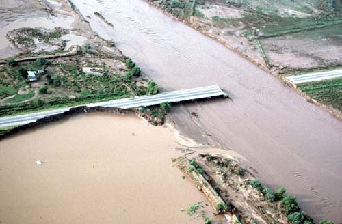
The City of Tucson�s Stormwater Master Plan is an ongoing effort to develop a comprehensive stormwater management plan with a regional, watershed focus. A comprehensive program covering an entire watershed provides a much more favorable basis to plan present and future runoff management needs. A �system� or watershed approach also enables the city to minimize its reliance on structural stormwater control solutions and better preserve and enhance natural water courses. To help accomplish its goal, the master plan has identified 59 urban watersheds within six general hydrologic units or areas with similar geographic and hydrologic characteristics, all located within Tucson. In this context, a watershed is defined as a geographical area which contributes stormwater runoff to a particular point. During Phase II of the stormwater study a database was established that included information on the physical characteristics of the drainage systems in each of the city�s 59 watersheds. The study established a prioritization scheme to identify how individual watersheds ranked with regards to the potential for stormwater quality problems. Watersheds were examined by looking at human and natural considerations affecting them. Factors considered include estimated contaminant loadings, locations and extent of industrial and commercial areas as well as the existence of riparian areas. Santa Cruz River Watershed Basin Project An ongoing Santa Cruz River Watershed Basin study is addressing flooding and other issues. The Santa Cruz River watershed covers approximately 8,600 square miles in Southern Arizona. The watershed study is concentrating on the portion of the Santa Cruz River system within Pima County. The intent of the project is to address a cluster of public concerns including environmental resources, floodplain management, regulatory activities, erosion control, wastewater management, groundwater management and flood control. The goal of the study is to develop a basin management plan for the Santa Cruz River system. This plan is to guide future projects attempting to balance watershed concerns of environmental protection/restoration and economic development. Projected benefits of the project include a flood control river plan; land-use and regulatory tools for balancing competing uses; a protection and management guide for existing and future riparian areas; a river maintenance guide to maintaining flood conveyance and storage capacity while protecting environmental resources; and water quality identification and recharge opportunities. The U.S. Army Corps of Engineers is conducting the study, with the involvement of state, county, city and other federal agencies, San Xavier District of the Tohono O�odham Nation, International Boundary and Water Commission and various public and private interest groups. The study is expected to cost $2 million, to be shared between federal and non-federal partners, and to be completed January 2000. For many years people have looked for ways to keep more river water in the area, rather than letting it flow downstream to Pinal County. They noted the construction of dams along the Salt River which retain water in reservoirs to be released for later use. A major difference between the Santa Cruz watershed and the Salt River watershed, however, is that no practical sites for large storage dams are located along the Santa Cruz River or its tributaries.
In recent years, the U.S. Bureau of Reclamation, the U.S. Army Corps of Engineers and Pima County have looked at the feasibility of using inflatable dams to detain water temporarily so that it will infiltrate the riverbed and seep underground. Inflated to capture runoff, the dams can be deflated when major flooding could pose a threat to the structure. So far no project has been built. Artificial Instream Recharge Artificial recharge is discussed in Chapter 3. In this section we look at the possible impacts of instream recharge projects on rivers. Many people view streambeds as ideal locations for artificial recharge since streambeds generally provide the best sites for natural recharge. Artificial recharge in riverbeds may even be seen as recreating historic conditions of river flow. While streambed recharge has many benefits, projects must be carefully designed so that they do not lead to increased flood problems downstream. If the river is already flowing at the time of a large flood event, flood impacts may increase, depending on the quantity of the cumulative flow. If the flood event occurs when the channel alluvium and basin fill are saturated with water, mounding of recharge water may cause less storm water to infiltrate in the area of the recharge project and more recharge to occur downstream instead. In some cases it will occur out of the range of the major wells. Streambed recharge projects also may increase vegetation in the channels as a result of more available soil moisture. This vegetation could increase the risk of flood damage because it reduces the amount of water that the stream channel can carry. This vegetation, however, also can have many advantages from an aesthetic point of view, as wildlife habitat and for recreational use. The issues are obviously complex, and proposed artificial recharge projects should be carefully studied both for their recharge potential and for their impacts on flooding. Each instream recharge project must be evaluated individually, since conditions vary so much from site to site that no generalizations about the impacts of recharge on flooding will apply to all situations.
|