| ch. 1, pp. 1 - 2 |
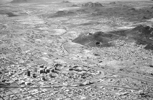
Southern Arizona is located within a physiographic region called the basin and range province. The region, which stretches from Nevada southeast to northern Mexico, is characterized by mountain ranges running in a roughly north-south orientation, interspersed with broad flat valleys or deep basins. (See Figure 1-1.) Tucson is located within a broad valley, with mountains on each side — Santa Catalinas to the north, the Rincons to the east, the Tucson Mountains to the west and the Santa Ritas to the south. Most of the population of the greater Tucson area lives in the Santa Cruz Valley. About 10,000 years ago, before the climate began to get warmer and drier, much more moisture reached the basin than does today. Water isotope studies show that much of the water now stored underground fell as rain during these ancient times. The alluvial soil that holds the subsurface water is called the aquifer. Alluvial soil or alluvium, which consists of clay, sand and rock, washed from the surrounding mountains and accumulated over many thousands of years. Groundwater is stored in the open spaces between the particles of sand and rock within the alluvium.
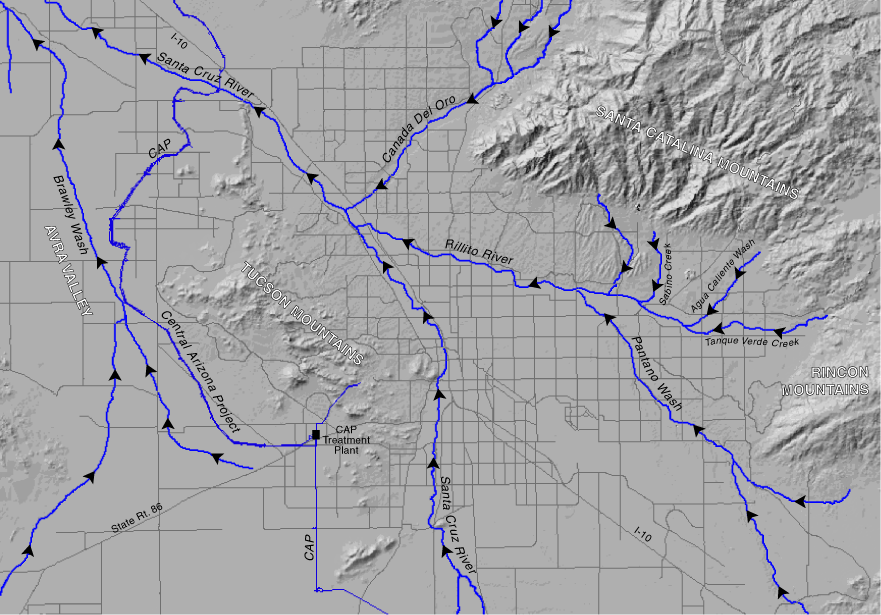
As is shown in Figure 1-2 various water courses transect the area. When flows occur, the Santa Cruz River runs north-northwest through the area, and the Rillito Creek runs from southeast to west, connecting with the Santa Cruz River near Orange Grove Road. The Pantano Wash flows northwest and enters the Rillito Creek before the Rillito connects with the Santa Cruz River. In years of heavy precipitation, some water will flow north to reach the Gila River west of Phoenix, then continue to the Colorado River and the Gulf of California. But in most years, flows do not get that far. The basin’s low annual precipitation results in very few streams or rivers with perennial (year-round) flow today. The most notable exception, Sabino Creek, begins at relatively high elevations and is supplied by snowmelt as well as rainfall. Most of the rivers, streams and washes in the Tucson Basin are ephemeral (i.e., they flow only immediately after rains). Overall scarcity and variability of flow has made surface water an unreliable and largely impractical water supply for a large population. Historically, the groundwater table in the Tucson area was much higher, and surface water and groundwater were connected along much of the Santa Cruz River. At that time the water table was high enough to feed the river. This no longer occurs because the water table levels have dropped far below the surface due to groundwater pumping. Global Circulation At 32.2° north latitude, Tucson lies along an arid and semi-arid zone that stretches from North Africa (Marrakech 31.2, Tripoli 32.7), the Middle East (Jerusalem 31.8, Baghdad 33.3), across Southwest and South Asia (Iran, Afghanistan, Pakistan), and into Central Asia (Tibet). (See Figure 1-5.) Air over the equator heats, rises, loses moisture and then sinks at about 30 degrees north latitude, creating large cells of stable high pressure. With low moisture content, and little to disturb the airflow, precipitation is sparse and infrequent along this global desert zone. Tucson Precipitation
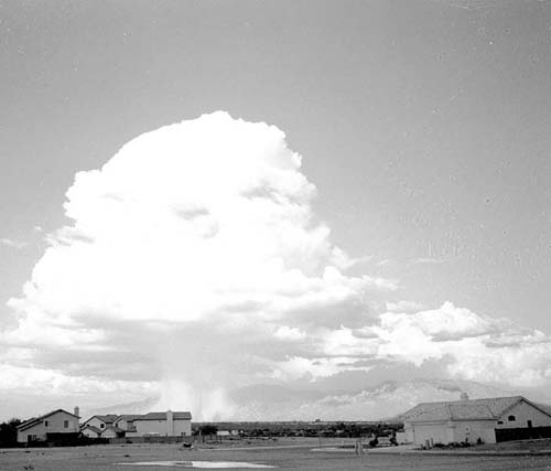
An annual average of 12 inches of rain falls within the Tucson Basin. Rainfall varies greatly according to the season and the location within the area. The mountains ringing the basin, particularly the Santa Catalinas, cause some local uplifting of air masses (orographic effect) resulting in annual precipitation as high as 28 inches on Mt. Lemmon. The east side of the mountain range gets less rain than the rest of the range. The precipitation arrives in two distinct seasons. Fifty-two percent falls during a summer “monsoon” (July–September) and 28 percent from December through March. In the summer, as land temperatures rise, dense, moist air from the Gulf of California and Gulf of Mexico is drawn inland. In the afternoon, as temperatures reach their peak, the moist air is pushed upwards, forming large thunderheads. Summer “monsoon” rains are characterized by brief but intense thunderstorms with highly localized precipitation. (See Figure 1-3.)
In the winter, large fronts develop over the Pacific Ocean. The global circulation patterns, and specifically the jet stream, carry these storms eastward. The persistent high pressure normally diverts the jet stream and storms away from the Southwest. In the late fall, however, the high pressure cell is weakened and can be displaced, allowing large, slow-moving fronts to pass over the Tucson Basin. Winter rains are characterized by heavy cloud cover and precipitation that persists for many hours or even several days and covers most of the area.
|