| ch. 5, pp. 55 - 57 |
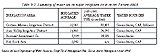
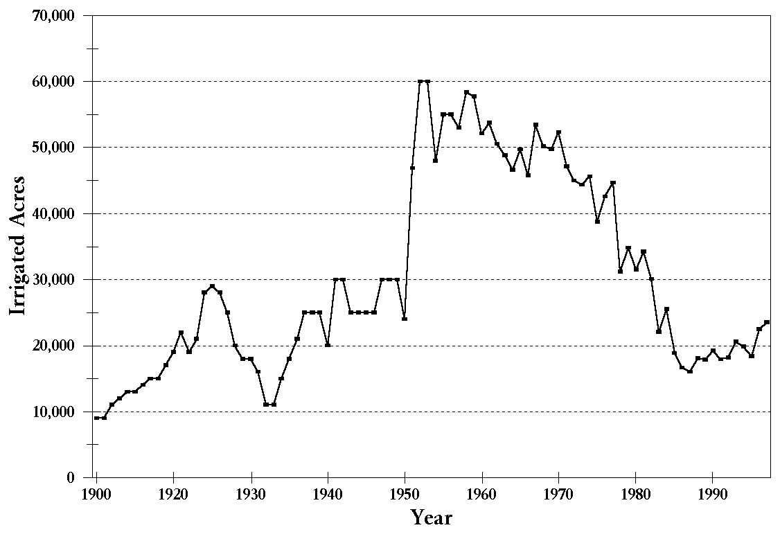
Not all Tucson citizens are committed to a water conservation ethic. Some people do not believe a water shortage exists, especially now when Arizona has more CAP water than it can use and faces the prospect of California or Nevada claiming the state�s unused portion. Other people believe they have a right to as much water as they are willing to pay for, to use as they see fit. Some critics claim such people may indulge in excessive water use but, in response, they may claim theirs is an essential use of water. Not all people appreciate landscaping with low-water use native plants; some prefer green lawns all year long. While some people consider golf courses a recreational necessity or a way to raise property values, others believe such facilities waste valuable water and benefit only the few who use them. Some people are reluctant to save water because they perceive conservation as a cynical means to justify population growth. Such skeptics argue the main reason business interests support conservation is to save water that then can be used to enable more people to move into the area. In this scenario, conservation efforts may result in reducing existing water use, but a growing population would soon consume whatever water savings are achieved. Agriculture has been the predominant user of water in Arizona in the 20th century. Since the 1940s, agriculture has accounted for about 80 to 90 percent of Arizona�s water use. In the Tucson area, agriculture�s share of water use in the Upper Santa Cruz Basin (which excludes the Avra Valley) was about 84 percent in 1940, shrinking to about 73 percent by 1951. The general downward trend in agricultural water use has resulted mostly from a reduction in cropped acreage. Cropped acreage in Pima County reached a plateau in 1955 and remained fairly constant until 1975, at about 50,000 to 60,000 acres. Irrigated acreage declined after 1975 as farmland was developed for urban use along the Santa Cruz River floodplain, including the Marana area. The City of Tucson purchased over 20,000 acres of farmland in the Tucson area from the 1950s to the early 1980s, taking that land out of agricultural production in order to use its water rights for municipal purposes.
After declining through the 1980s and early 1990s, agricultural water use increased to 132,700 acre-feet in 1997. Use in 1997 includes 25,100 acre-feet of CAP water used in-lieu of groundwater under the groundwater savings program set up by the State of Arizona (See discussion below). Reasons for the increase in agricultural water use are not clear. Rules for participation in the groundwater savings program allow use of renewable water supplies only in place of groundwater that otherwise would have been pumped. Other reasons for the increase that have been cited include better market conditions and the passage of the Federal Agriculture Improvement and Reform Act of 1996. This act removed federal price support programs and increased pressure on farmers to plant as many acres as possible to cover overhead costs. Agricultural water use in TAMA is regulated under the Groundwater Management Act of 1980 (GMA). The GMA regulates agricultural water use in several ways. First, no new agricultural land can be developed for irrigation. Second, farms are given a maximum annual allotment of groundwater to be used for irrigation. This is based on the historic amount of irrigated acres on a farm in the five years before the GMA and an amount of water to be used per acre, called a water duty. This irrigation water duty will be reduced over time as increasing water application efficiencies are required (See Chapter 7 for more detail). Farms using less than their groundwater allowance are given a credit for the difference between their actual water use and the groundwater allowance. These credits are accumulated in a flexibility account and can be used in future years, if needed, to meet conservation requirements. There is no limit to the number of flexibility credits that can be accumulated.
Annual groundwater allotments were set near the historic peak of irrigated acreage; thus much more groundwater than is needed is legally available to farmers each year. With irrigation efficiencies increasing on farms and significant amounts of farmland out of production, many farms have accumulated large flexibility account balances. On average, TAMA farms were using 50 to 60 percent of their groundwater allowances. ADWR projects that, even as required irrigation efficiencies are raised to 85 percent, most farms will still accumulate credits. The existence of large flexibility account balances hinders the ability of agricultural conservation requirements to affect agricultural water use.
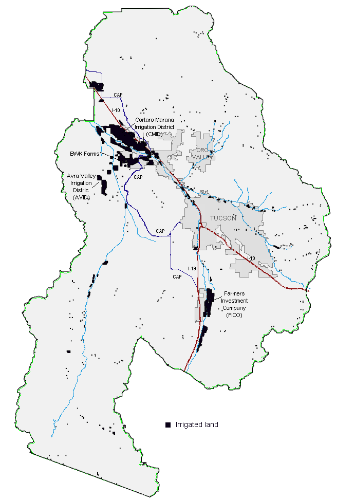
As shown in Figure 5-12, four main groups of farms are clustered in three agricultural areas remaining within TAMA. Two irrigation districts are operating in TAMA: Cortaro Marana Irrigation District (CMID), located north and west of the Town of Marana, and Avra Valley Irrigation District (AVID), located generally just south of CMID, southwest of the Santa Cruz River. Irrigation also is occurring in what is referred to as the Red Rock area, in the Pinal County portion of TAMA. Farms within the Farmers Investment Company (FICO) near Green Valley account for most of the rest of TAMA agricultural land. Agricultural water use in other areas of TAMA, such as the Tucson area, the Altar Valley and farmland in the Arivaca area, accounts for less than three percent of total agricultural water use in TAMA. The San Xavier (south of Valencia Road) and Schuk Toak districts (western Avra Valley) of the Tohono O�odham Nation have CAP allocations, which may be applied to restore historic farmlands and add additional farmland. Projections show that about 5,000 acre-feet of CAP water may be used on the San Xavier District by the year 2005. The Schuk Toak District currently is developing a farm which is expected to use 10,800 acre-feet of CAP water per year by 2010. A pipeline to supply CAP water to the San Xavier District is now under construction.
|