| ch. 3, pp. 28 - 30 |
Recharging the Central Wellfield The highest rate of groundwater decline in TAMA is occurring in the Central Wellfield, and USGS models project that subsidence in that part of TAMA could greatly increase. Artificial recharge has been suggested as one way of stopping declines of groundwater levels in the Central Wellfield, and the WCPA directs the City of Tucson to recharge the Central Wellfield. Although artificial recharge could help reduce groundwater level declines in the Central Wellfield, determining the best method of recharging the area is difficult, and recharging large amounts of water requires extensive facilities. With current withdrawals from the Central Wellfield ranging from 60,000 to 70,000 acre-feet per year and natural recharge estimated at 17,000 acre-feet per year, 43,000 to 53,000 acre-feet per year of recharge would be required to stop the decline of groundwater levels. This is a great deal of water to recharge every year in central Tucson.
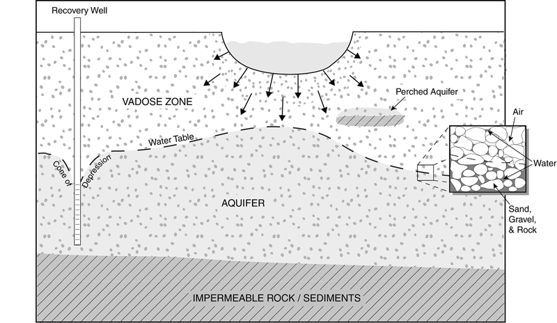
One possible way of recharging the Central Wellfield is by releasing CAP water into the Rillito Creek, Tanque Verde Creek and the Pantano Wash. These stream channels generally overlap the Central Wellfield, although most of their flows are to the north-northwest, not toward the Central Wellfield. The high infiltration rates in local stream channels would seem to support the premise that large amounts of CAP water could be successfully recharged using such channels to replenish the Central Wellfield. The long-term recharge rate, however, often differs from the short-term surface infiltration rate. The short-term rate is the rate at which water enters the coarse-grained channel alluvium. Water generally infiltrates this alluvium very easily. The long-term recharge rate is the rate at which water actually reaches the aquifer, and is determined by basin fill deposits closer to the aquifer. Because these deposits are less permeable than the recently deposited alluvium near the surface, the long-term recharge rate is lower than the short-term infiltration rate. If water were released in the stream channel over a long period of time (perhaps greater than a year), water would mound up in the channel alluvium. Water then would eventually rise to the stream channel, and water released at the surface would infiltrate at the long-term rate, or be rejected as subflow or surface flow. A panel of hydrologists and other technical experts formed by ADWR in 1996 estimated the maximum long-term average annual volume of artificial recharge possible in stream channels generally overlying the Central Wellfield (Rillito Creek, Tanque Verde Creek and the Pantano Wash). The panel concluded that the maximum long-term average annual volume that could be effectively infiltrated through those channels is approximately 29,000 acre-feet. When the volume of natural recharge is considered, total maximum potential average annual volume of artificial and natural recharge in the stream channels is approximately 50,000 acre-feet per year. Some of these stream reaches have landfills, however, containing contaminants that could pollute recharged water. After excluding stream reaches with known landfills, the maximum long-term average annual volume of artificial and natural recharge would be about 27,000 acre-feet, or only 38 to 44 percent of present annual withdrawals from the Central W ellfield. Recharge experts also have pointed out that some of the water which infiltrates the stream channels generally overlying the Central Wellfield may not reach the underlying aquifer. This is because some of the water applied to local stream channels would likely move downstream as subsurface groundwater flow just beneath the streambed instead of recharging the Central Wellfield. This subflow would travel downgradient to the alluvium underneath the Santa Cruz River after its confluence with the Rillito Creek and move towards Pinal County. Any of this subflow eventually reaching the aquifer would be too far from the Central Wellfield to benefit it. Preliminary results of attempts to date groundwater based upon isotopic analyses indicate that groundwater located a couple miles south of the Rillito is hundreds or thousands of years old. This suggests that limited recharge of the Central Wellfield is occurring. The City of Tucson is planning to address water decline problems in the Central Wellfield by pumping instead from CAVSARP. The projected full-scale capacity of CAVSARP is 60,000 acre-feet per year. If enough water is recovered annually from CAVSARP to offset current annual pumping in the Central Wellfield, most of the Central Wellfield groundwater pumps could be shut off. Groundwater level declines could then be stopped or slowly reversed with the help of natural recharge. Water recovered from CAVSARP would be sent though the Hayden-Udall (CAP) Treatment Facility before being delivered to homes. USGS has begun a project to study the location and timing of recharge in the 12-mile stretch of the Rillito Creek from Craycroft Road to the Santa Cruz River. Approximately $635,000 is budgeted to collect the needed data and build groundwater models to investigate various recharge scenarios. This study is expected to greatly improve assessment of the feasibility of artificial recharge in the Rillito Creek to benefit the Central Wellfield. (For more information see Chapter 4.)
In response to our ongoing water worries, various strategies have been proposed to increase regional water supplies of our region. Options for increasing water supplies in Tucson, however, are limited. Using CAP water is currently Tucson�s only major strategy for increasing water supplies. Whether it is used directly in municipal systems or by agriculture or mines, or whether it is recharged for later use, CAP water can add considerably to the basin supply. Use of effluent does not bring new water into the basin, but does help prolong the water supplies by reducing the need to use stored groundwater. .
|