
ESC project draws a crowd
visitors' day at savannah river is a success
On August 29 people curious about the Expedited Site Characterization project at the U.S. Department of Energy'sSavannah River Site in South Carolina met in nearby Augusta, Georgia to hear encouraging words from ESC boosters. The visitors, including DOE personnel and contractors, private-sector consultants, federal and state regulators, and stakeholders, then toured the D-Area Oil Seepage Basin at the Savannah River Site where ESC is being applied. The project team described Expedited Site Characterization as a methodology that offers the potential to reduce the time-sometimes by years-it can take to characterize a site before a cleanup plan can be chosen.
 Thomas Starke of Los Alamos National Laboratory reported on the cost effectiveness of ESC as it was used by Argonne National Laboratory at the Pantex Plant in Texas in 1994 and 1995. He estimates using ESC has saved 25 to 60 percent in schedule and 60 percent in costs over traditional site characterization.
But ESC is much more than streamlined site characterization; it is also a rational process to produce a better, more useful site characterization. ESC is not a particular set of technologies, but a process based on the specific geologic conditions at a site. In an ESC scenario, an experienced multi-disciplinary team gathers data using an appropriate mix of innovative and baseline technologies. On-site mobile labs may be used to quickly analyze the data. The team members integrate geophysical, geotechnical, and hydrologic data to refine their understanding of the site and to facilitate the next round of decisions. The crucial elements of ESC include:
- An experienced multi-disciplinary team working on-site to fill in data gaps and explain data that may initially appear contradictory,
- Introduction of appropriate innovative technologies into the process to complement and enhance baseline technologies,
- Immediate data integration to gain a progressively clearer picture of the stratigraphy of the site, how it has affected contaminant flow, and plan for logical boring or well placements and data samplings,
- A dynamic work plan acceptable to regulators that can be modified in response to incoming data,
- Validation of the methodology by using an evolving conceptual model of the site to predict data results and measurements.
The ESC project at Savannah River is being financed by DOE's Office of Technology Development and led by Ames
Laboratory, a DOE laboratory at Iowa State University in Ames, Iowa. The project has received approval from U.S. EPA Region IV and South Carolina Department of Health and Environmental Control regulators, who meet frequently with the team to review progress and approve modifications of the work plan.
Al Bevolo, senior scientist at Ames and ESC principal investigator, explained how ESC is being applied to the D-Area Oil Seepage Basin, an area of approximately 240 by 440 feet. From 1952 to 1975 a series of unlined seepage trenches received waste oils from the central powerhouse, a heavy water production facility, and a support laboratory. In 1975 the basin, containing a foot of standing liquid and an unknown number of 55-gallon drums, was backfilled.
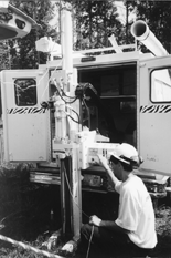
After setting up in June 1995, the ESC team's Phase I objectives were to first gain a clearer understanding of the subsurface geology and determine how it has affected the movement of the contaminants; and then obtain soil and groundwater samples to determine site contaminants. The team began by studying the results from an earlier remedial investigation that had installed six piezometers and four monitoring wells. The team drilled two new boreholes, installed piezometers, and measured for natural gamma, density, porosity, and conductivity of the soil. New data was examined for correlations with data from existing piezometers and wells. Ground penetrating radar was used to locate buried materials and detail the stratigraphy below the surface. Surface electromagnetic conductivity techniques were used to define lateral geologic variability and help locate buried materials.
Knowledge gained about the location of soil types, strata, and buried materials helped the team make predictions about where to take soil and water samples and how many to take. The samples were analyzed and levels of site-specific contaminants were determined. On July 20 the ESC team met with EPA and state regulators to share the results of testing and to compare contaminant levels with agreed-upon levels of cleanup.
In Phase II, the team is concentrating on obtaining a detailed hydrogeologic characterization and determining the full extent of contaminants. The surface geophysical measurements which indicated general lateral trends in geologic conditions and distribution of contaminants during Phase I guides the team in its judicial use of more sensitive and costly sampling techniques in Phase II. Push technologies such as cone penetrometers are classifying soil and determining pore pressure. Geoprobes are measuring conductivity for evidence of inorganic contamination. On-site mobile laboratories are analyzing the data-gas chromatograph/electrical conductivity detector for pesticides; an inductively coupled plasma and a graphite furnace atomic absorption unit for metals; a gas chromatograph, chromatograph, and mass spectrometer for volatile organic compounds. Computers provide graphical displays of data.


