|
Mercury wet deposition involves the transfer of mercury
from the atmosphere to land or water through precipitation. Several
chemical species of mercury exist in ambient air as a result of both
natural and man-made emissions and the water-soluble forms may be scrubbed
out of the atmosphere by cloud water or rain and snowfall. For many
sensitive surface waters, atmospheric wet deposition constitutes the most
significant route of mercury input. Dry deposition processes also
contribute to the overall rate of atmospheric deposition, but wet
deposition is believed to play a larger role in the eastern United States
where precipitation rates are higher than in arid western states.
Together, these phenomena can contribute to raise methylmercury levels in
fish in mercury-sensitive waters.
 Wet
deposition data is generated through the collection and subsequent
analysis of rainfall for total mercury concentration. The DAQ has operated
two sites for measurement of mercury in rainfall since 1996. Both
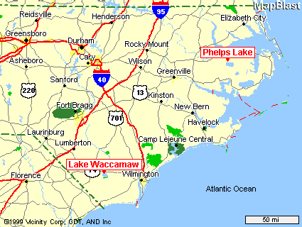
deposition monitors are located in the eastern part of the state near
mercury-sensitive waters; one at Pettigrew State Park on the shores of
Phelps Lake in Washington County (NC42)*, and the other at Waccamaw State
Park in Columbus County (NC08). Data collected from these stations are
provided to the National Atmospheric Deposition Program Mercury Deposition
Network (MDN) to aid in the
identification of geographical and temporal trends in mercury
deposition across the U.S. Rainfall is collected weekly in a bucket
sampler and sent to a laboratory for quantitative analysis. Mercury levels
are measured using EPA Method 1631
for total mercury analysis and undergo full quality assurance/quality
control procedures before being reported. Data are presented in two
formats: volume-weighted mercury concentration in rainwater (ng/L), and
deposition rate (ng/m2). Annualized values are presented in the
following table for both North Carolina sites, 1996 - 1999. Wet
deposition data is generated through the collection and subsequent
analysis of rainfall for total mercury concentration. The DAQ has operated
two sites for measurement of mercury in rainfall since 1996. Both
deposition monitors are located in the eastern part of the state near
mercury-sensitive waters; one at Pettigrew State Park on the shores of
Phelps Lake in Washington County (NC42)*, and the other at Waccamaw State
Park in Columbus County (NC08). Data collected from these stations are
provided to the National Atmospheric Deposition Program Mercury Deposition
Network (MDN) to aid in the
identification of geographical and temporal trends in mercury
deposition across the U.S. Rainfall is collected weekly in a bucket
sampler and sent to a laboratory for quantitative analysis. Mercury levels
are measured using EPA Method 1631
for total mercury analysis and undergo full quality assurance/quality
control procedures before being reported. Data are presented in two
formats: volume-weighted mercury concentration in rainwater (ng/L), and
deposition rate (ng/m2). Annualized values are presented in the
following table for both North Carolina sites, 1996 - 1999.
| Table 1: Annual cumulative mercury
wet deposition and precipitation rates, and volume-weighted mercury
concentration, 1996-99. |
| |
Waccamaw Site |
Phelps Site |
| Year |
Annual Cumulative Wet
Deposition
(ng/m2/yr) |
Precip.
(mm/yr) |
Vol-wt
conc.
(ng/L) |
Annual Cumulative Wet
Deposition
(ng/m2/yr) |
Precip.
(mm/yr) |
Vol-wt
conc.
(ng/L) |
| 1996 |
12821 |
1087.6 |
11.8 |
12361 |
1336.0 |
9.3 |
| 1997 |
10430 |
996.0 |
10.5 |
9321 |
985.6 |
9.5 |
| 1998 |
15830 |
1265.7 |
11.6 |
9939 |
1395.5 |
7.1 |
| 1999 |
14832 |
8.0 |
11.6 |
7684 |
1139.7 |
6.7 |
Data from 1996-1998 are reported in Table 1 if they met
the MDN criteria for valid samples. Data from 1999 are preliminary and
have not been fully quality assured by the MDN program office. On a
handful of occasions, data were rejected. Reasons for rejecting data
included site operation problems and sample collection or processing
problems.The net effect of these exclusions is to decrease estimates of
cumulative deposition. It cannot be said what impact these missing data
have on the calculation of volume-weighted average mercury
concentration.
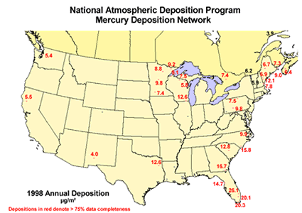 Annual wet
deposition rates in eastern North Carolina are similar to other locations
in the United States (see figure at right). Wet deposition rates are
influenced by rainfall amount and rainwater mercury concentration. Mercury
is added to rainwater through cloud-level chemical reactions and/or
scrubbing out of reactive gaseous mercury (RGM) or particulate mercury
from the air column as the rainwater falls to earth. Local emissions may
play a role in this variable, especially under the right meteorological
conditions (Dvonch, 1998). Reporting volume-weighted mercury
concentrations reduces the relative influence of small precipitation
events and provides a better indication of longer-term trends in mercury
rainwater concentration. This means of reporting does not, however,
capture short-term trends in temporal or spatial variability which may be
a better indicator of local-scale impacts. Annual wet
deposition rates in eastern North Carolina are similar to other locations
in the United States (see figure at right). Wet deposition rates are
influenced by rainfall amount and rainwater mercury concentration. Mercury
is added to rainwater through cloud-level chemical reactions and/or
scrubbing out of reactive gaseous mercury (RGM) or particulate mercury
from the air column as the rainwater falls to earth. Local emissions may
play a role in this variable, especially under the right meteorological
conditions (Dvonch, 1998). Reporting volume-weighted mercury
concentrations reduces the relative influence of small precipitation
events and provides a better indication of longer-term trends in mercury
rainwater concentration. This means of reporting does not, however,
capture short-term trends in temporal or spatial variability which may be
a better indicator of local-scale impacts.
Both North Carolina deposition monitors are situated in
relatively remote locations, at least 20 kilometers away from any urban
activity that might be responsible for significant mercury emissions. The
Waccamaw site, however, is more likely to be influenced by local
industrial activity since it is located approximately 15 miles from a
major atmospheric mercury emissions source and about 30 miles from
Wilmington, NC. The Phelps site, which is surrounded by parkland and
agricultural activities and free of local or regional mercury emissions
sources, could be thought of as a good representation of "background"
conditions for the eastern coastal plain of North Carolina.
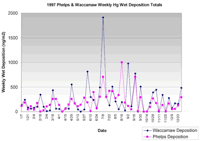 An illustration
of week-to-week variability in mercury deposition can be seen in the
figure at right, which presents data collected during 1997. The high
degree of variability in weekly wet deposition rates is primarily due to
differences in precipitation levels. However, mercury concentration also
seems to play a role in the observed variability. Variation in rainwater
mercury concentration is significant when examined on a week-to-week
basis. The weekly values for the Lake Waccamaw site ranged from 3.09 ng/L
to 49.04 ng/L during 1997. At Phelps, the range extended from 1.74 ng/L to
26.98 ng/L. An even wider range of values has been reported for
precipitation captured in southeastern Florida (Dvonch 1998). In the
Florida study, individual rain event samples were collected at 17 sites
between August 6 and September 6, 1995. The variability in event mercury
concentration for all sampling sites was substantial, with reported values
ranging from 4.5 ng/L to 113.2 ng/L. Monthly volume-weighted mean
concentrations fluctuated from 13.1 ng/L to 30.5 ng/L, a range similar to
those values calculated from North Carolina data. It is interesting to
note that in addition to a consistent pattern of lower annual
volume-weighted average mercury concentrations there is also a tighter
range of weekly mercury precipitation concentrations at the Phelps site.
This is consistent with predictions for a rural location unaffected by
local mercury sources (EPA). An illustration
of week-to-week variability in mercury deposition can be seen in the
figure at right, which presents data collected during 1997. The high
degree of variability in weekly wet deposition rates is primarily due to
differences in precipitation levels. However, mercury concentration also
seems to play a role in the observed variability. Variation in rainwater
mercury concentration is significant when examined on a week-to-week
basis. The weekly values for the Lake Waccamaw site ranged from 3.09 ng/L
to 49.04 ng/L during 1997. At Phelps, the range extended from 1.74 ng/L to
26.98 ng/L. An even wider range of values has been reported for
precipitation captured in southeastern Florida (Dvonch 1998). In the
Florida study, individual rain event samples were collected at 17 sites
between August 6 and September 6, 1995. The variability in event mercury
concentration for all sampling sites was substantial, with reported values
ranging from 4.5 ng/L to 113.2 ng/L. Monthly volume-weighted mean
concentrations fluctuated from 13.1 ng/L to 30.5 ng/L, a range similar to
those values calculated from North Carolina data. It is interesting to
note that in addition to a consistent pattern of lower annual
volume-weighted average mercury concentrations there is also a tighter
range of weekly mercury precipitation concentrations at the Phelps site.
This is consistent with predictions for a rural location unaffected by
local mercury sources (EPA).
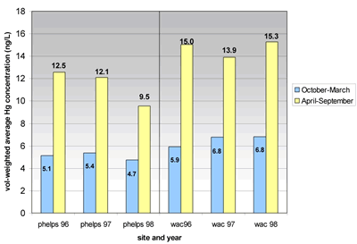 A pattern of
elevated mercury concentrations during summer months can be observed when
the data are separated by season (see figure at left). Data from 1996 and
1997 have been split into two groupings: April - September and October -
March. During the April - September time period, the average
volume-weighted mercury concentration in rainwater is over twice that
detected during the remainder of the year. Some of this difference might
be explained by seasonal changes in air movement. During summer months
winds predominantly arrive from the southwest, while winds from the north
or northwest influence wind patterns during winter months. Conceivably, if
these sampling sites were downwind of sources during one half of the year
and upwind during the remainder, a pattern might emerge from the data.
However, higher summertime readings are seen consistently at other MDN
sampling sites on the east coast so it seems unlikely that this is the
only phenomenon at work. Some have suggested that warmer temperatures will
facilitate atmospheric reactions that create RGM from elemental mercury
and thus increase the potential for deposition (Mason, 2000). Other
potential reasons could include meteorological transport phenomena,
precipitation scavenging efficiency (rain vs. snow) or the amount of
sunlight. At present the relative impact of local atmospheric mercury
sources cannot be determined by examining seasonal data without more
complete information on local and mesoscale meteorological conditions
during individual rain events. A pattern of
elevated mercury concentrations during summer months can be observed when
the data are separated by season (see figure at left). Data from 1996 and
1997 have been split into two groupings: April - September and October -
March. During the April - September time period, the average
volume-weighted mercury concentration in rainwater is over twice that
detected during the remainder of the year. Some of this difference might
be explained by seasonal changes in air movement. During summer months
winds predominantly arrive from the southwest, while winds from the north
or northwest influence wind patterns during winter months. Conceivably, if
these sampling sites were downwind of sources during one half of the year
and upwind during the remainder, a pattern might emerge from the data.
However, higher summertime readings are seen consistently at other MDN
sampling sites on the east coast so it seems unlikely that this is the
only phenomenon at work. Some have suggested that warmer temperatures will
facilitate atmospheric reactions that create RGM from elemental mercury
and thus increase the potential for deposition (Mason, 2000). Other
potential reasons could include meteorological transport phenomena,
precipitation scavenging efficiency (rain vs. snow) or the amount of
sunlight. At present the relative impact of local atmospheric mercury
sources cannot be determined by examining seasonal data without more
complete information on local and mesoscale meteorological conditions
during individual rain events.
Currently, data is only available on wet deposition
patterns in North Carolina. It is believed that dry deposition also occurs
in the absence of precipitation, involving RGM and particulate mercury
species (EPA). The net effect of this phenomenon would be to increase the
overall rate of deposition relative to that predicted using data for wet
deposition only. At this point, it is difficult to speculate what the
relative impact of dry deposition is in North Carolina. It is likely that
dry deposition occurs to a significant extent near RGM emission points,
especially those which emit at ground level where significant scavenging
by foliage could take place. This is an important phenomenon to consider,
as dry deposition could result in substantial direct and indirect inputs
of mercury to waterways located near mercury emission sources. In the near
future, the DAQ will acquire more complete information on ambient levels
of RGM to assess the potential for dry deposition and source impacts on
mercury-sensitive areas. The Lake Waccamaw area is characterized by some
of the highest levels of mercury in fish in the state; the identification
of atmospheric inputs to this area could aid in ameliorating this
situation if proper steps are taken to reduce mercury emissions.
For more information on mercury deposition trends in
North Carolina, please contact Jeff Hayward with the Toxics
Protection Branch at (919) 733-1475.
* During the summer of 2000, the Phelps site will be
relocated to a National Wildlife Refuge area positioned between Phelps
Lake and Pungo Lake in Washington County. The new site will be located
less than 5 miles from the current site.
References:
Environmental Protection Agency (EPA) (1997). Mercury
Study Report to Congress. EPA-452/R-97-003.
Dvonch, et al (1998). An investigation of
source-receptor relationships for mercury in south Florida using event
precipitation data. The Science of the Total Environment, v 213,
pp 95-108.
Mason RP, et al (2000). Annual and Seasonal Trends in
Mercury Deposition in Maryland. Atmospheric Environment, v 34, pp
1691-1701. |