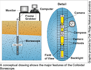
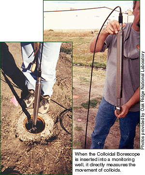
As a method for directly measuring groundwater flow rates and directions, the Colloidal Borescope is an alternative to tracer tests, which can be difficult, time intensive, and expensive to perform. When the Colloidal Borescope is inserted into a monitoring well, it directly measures the movement of naturally occurring particles in groundwater, or colloids, as they flow through a well’s screened interval, which corresponds to a distinct lithographic unit in the subsurface. Various depths within a single screened interval can be evaluated. The resulting data provide a vertical distribution of groundwater flow directions and velocities, which is useful in helping map the hydrogeologic composition of a site, as well as interpreting contaminant migration in complex flow systems. The instrument’s data can also be used to indicate the effects on groundwater flow rates of man-made intrusions, such as drainage ditches, outfalls, and leaking utilities. The Colloidal Borescope consists of a CCD (charge-coupled device) camera, a flux-gate compass, an optical magnification lens, an illumination source, and stainless steel housing. The device is approximately 89 cm long and has a diameter of 44 mm, so it can be easily inserted into a 5-cm-diameter monitoring well. Upon insertion into a well, the device produces an electronic image magnified 140X, which is transmitted to the surface, where it is viewed and analyzed. The flux-gate compass is used to align the borescope in the well. As colloids pass beneath the lens, the back lighting source illuminates them in a manner similar to a conventional microscope with a lighted stage. A video frame grabber digitizes individual video frames at intervals selected by the operator. A software package developed by Oak Ridge National Laboratory compares two digitized video frames, matches colloids from the two images, and assigns pixel addresses to the particles. Using this information, the software program computes and records the average particle size, number of particles, and their speed and direction. A computer analyzes flow measurements every four seconds, resulting in a large database after only a few minutes of observations. Since standard VHS video uses 30 frames per second, a particle that moves 1 mm across the field of view can be captured in subsequent frames 1/30 of a second apart, resulting in an upper measurement velocity range of 3 cm/s. For low-flow conditions, the operator can set longer intervals of time between frames, resulting in a lower velocity range for stagnant-flow conditions. Plotting the movement of a
plume Groundwater flow and contaminant transport in fractured, porous aquifers is complicated by flow in the porous blocks. Flow in sandstone or siltstone blocks may be in the direction of the hydraulic gradient while groundwater in the fractures will migrate in a direction parallel to the fractures. It is a combination of these characteristic flows that ultimately determines the actual direction of contaminant migration in fractured porous systems. In the East Mountain site, the hydraulic gradient trended in a northwest direction, while the faults ran in a north-south direction. Results from the Colloidal Borescope indicated that groundwater velocities in the fracture zones are approximately one order of magnitude higher than those in the unfractured zones. This evidence suggests that the faults are acting as preferential flow zones, which dominate the groundwater flow component and redirect the hydrocarbon contamination from the northwesterly regional flow direction to a southern direction parallel to the fault trend. Results from the field investigation at the Sandia site have shown that the Colloidal Borescope is an effective tool for providing groundwater flow information in complex, fractured aquifers. The Colloidal Borescope provides direct measurements at specific locations and, when combined with other site information, provides a comprehensive understanding of groundwater flow and contaminant migration. Monitoring cleanups As DOE moves closer to the day when its sites are turned over to the public,
instruments like the Colloidal Borescope, which can be used to monitor the status of
permeable reactive barriers and other long-term solutions to environmental problems, will
play a major role in DOE’s continuing stewardship responsibilities. For more
information about DOE’s investigations of the Colloidal Borescope, contact Nic Korte
at the Oak Ridge National Laboratory/Grand Junction Office at (970) 248-6210. The
vendor’s (AquaVISION) Web site at http://www.aquavisionenv.com
links to technical papers. |