
IV. STREAMBANK AND SHORELINE EROSION MANAGEMENT MEASURE
Streambank erosion is used in this guidance to refer to the loss of fastland along nontidal streams and rivers. Shoreline erosion is used in this guidance to refer to the loss of beach or fastland in tidal portions of coastal bays or estuaries. Erosion of ocean coastlines is not regarded as a substantial contributor of NPS pollution in coastal waterbodies and will not be considered in this guidance.The force of water flowing in a river or stream can be regarded as the most important process causing erosion of a streambank. All of the eroded material is carried downstream and deposited in the channel bottom or in point bars located along bends in the waterway. The process is very different in coastal bays and estuaries, where waves and currents can sort the coarser-grained sands and gravels from eroded bank materials and move them in both directions along the shore, through a process called littoral drift, away from the area undergoing erosion. Thus, the materials in beaches of coastal bays and estuaries are derived from shore erosion somewhere else along the shore. Solving the erosion of the source area may merely create new problems with beach erosion over a much wider area of the shore.
The seepage of ground water and the overland flow of surface water runoff also contribute to the erosion of both streambanks and shorelines. The role of ground water is most important wherever permeable subsurface layers of sand or gravel are exposed in banks and high bluffs along streams, rivers, and coastal bays (Palmer, 1973; Leatherman, 1986; Figure 6-10). In these areas, the seepage of ground water into the waterway can cause erosion at the point of exit from the bank face, leading to bank failure. The surface flow of upland runoff across the bank face can also dislodge sediments through sheet flow, or through the creation of rills and gullies on the shoreline banks and bluffs.
The erosion of shorelines and streambanks is a natural process that can have either beneficial or adverse impacts on the creation and maintenance of riparian habitat. Sands and gravels eroded from streambanks are deposited in the channel and are used as instream habitat during the life stages of many benthic organisms and fish. The same materials eroded from the shores of coastal bays and estuaries maintain the beach as a natural barrier between the open water and coastal wetlands and forest buffers. Beaches are dynamic, ephemeral land forms that move back and forth onshore, offshore, and along shore with changing wave conditions (Bascom, 1964). The finer-grained silts and clays derived from the erosion of shorelines and streambanks are sorted and carried as far as the quiet waters of wetlands or tidal flats, where benefits are derived from addition of the new material.
There are also adverse impacts from shoreline and streambank erosion. Excessively high sediment loads can smother submerged aquatic vegetation (SAV) beds, cover shellfish beds and tidal flats, fill in riffle pools, and contribute to increased levels of turbidity and nutrients. However, there are few research results that can be used to identify levels below which streambank and shoreline erosion is beneficial and above which it is an NPS-related problem.
The Chesapeake Bay is one coastal waterbody for which sufficient data exist to characterize the relative importance of shore erosion as a source of sediment and nutrients (Ibison et al., 1990, 1992). Erosion of the shores above mean sea level contributes 6.9 million cubic yards of sediment per year, or 39 percent of the total annual sediment supply to the Chesapeake Bay (USACE, 1990). The contribution of nitrogen from shore erosion is estimated at 3.3 million pounds per year, which is 3.3 percent of the total nonpoint nitrogen load to the Bay. The contribution of phosphorus from shore erosion is estimated at 4.5 million pounds per year, which is approximately 46 percent of the total nonpoint phosphorus load to the Bay (USEPA-CBP, 1991).
For many watersheds, it will be necessary to consider four questions about streambank and shoreline erosion simultaneously in developing an NPS pollution reduction strategy:
- Is sediment derived from coastal erosion helping to maintain aquatic habitat elsewhere in the system?
- Is coastal erosion a significant contributor of nonpoint sediment and nutrients?
- Is coastal erosion causing a loss of wetlands and riparian areas, with resultant loss of aquatic habitat and reduction of capacity to remove NPS pollutants from surface waters?
- Are activities along the shoreline and in adjacent surface waters increasing the rate of coastal erosion above natural (background) levels?
A. Management Measure for Eroding Streambanks and Shorelines
- Where streambank or shoreline erosion is a nonpoint source pollution
problem, streambanks and
shorelines should be stabilized. Vegetative methods are strongly preferred unless
structural methods are more cost-effective, considering the severity of wave and wind
erosion, offshore bathymetry, and the potential adverse impact
on other streambanks, shorelines, and offshore areas.
- Protect streambank and shoreline features with the potential to reduce NPS
pollution.
- Protect streambanks and shorelines from erosion due to uses of either the
shorelands or adjacent surface
waters.
1. Applicability
This management measure is intended to be applied by States to eroding shorelines in coastal bays, and to eroding streambanks in coastal rivers and creeks. The measure does not imply that all shoreline and streambank erosion must be controlled. Some amount of natural erosion is necessary to provide the sediment for beaches in estuaries and coastal bays, for point bars and channel deposits in rivers, and for substrate in tidal flats and wetlands. The measure, however, applies to eroding shorelines and streambanks that constitute an NPS problem in surface waters. It is not intended to hamper the efforts of any States or localities to retreat rather than to harden the shoreline. Under the Coastal Zone Act Reauthorization Amendments of 1990, States are subject to a number of requirements as they develop coastal NPS programs in conformity with this measure and will have some flexibility in doing so. The application of management measures by States is described more fully in Coastal Nonpoint Pollution Control Program: Program Development and Approval Guidance, published jointly by the U.S. Environmental Protection Agency (EPA) and the National Oceanic and Atmospheric Administration (NOAA) of the U.S. Department of Commerce.
2. Description
Several streambank and shoreline stabilization techniques will be effective in controlling coastal erosion wherever it is a source of nonpoint pollution. Techniques involving marsh creation and vegetative bank stabilization ("soil bioengineering") will usually be effective at sites with limited exposure to strong currents or wind-generated waves. In other cases, the use of engineering approaches, including beach nourishment or coastal structures, may need to be considered. In addition to controlling those sources of sediment input to surface waters which are causing NPS pollution, these techniques can halt the destruction of wetlands and riparian areas located along the shorelines of surface waters. Once these features are protected, they can serve as a filter for surface water runoff from upland areas, or as a sink for nutrients, contaminants, or sediment already present as NPS pollution in surface waters.Stabilization practices involving vegetation or coastal engineering should be properly designed and installed. These techniques should be applied only when there will be no adverse effects to aquatic or riparian river habitat, or to the stability of adjacent shorelines, from stabilizing a source of shoreline sediments. Finally, it is the intent of this measure to promote institutional measures that establish minimum set-back requirements or measures that allow a buffer zone to reduce concentrated flows and promote infiltration of surface water runoff in areas adjacent to the shoreline.
3. Management Measure Selection
This management measure was selected for the following reasons:
- Erosion of shorelines and streambanks contributes significant amounts
of NPS pollution in surface waters such as in the Chesapeake Bay;
- The loss of coastal land and streambanks due to shoreline and streambank
erosion results in reduction of riparian areas and wetlands that have NPS
pollution abatement potential; and
- A variety of activities related to the use of shorelands or adjacent surface waters can result in erosion of land along coastal bays or estuaries and losses of land along coastal rivers and streams.
4. Practices
As discussed more fully at the beginning of this chapter and in Chapter 1, the following practices are described for illustrative purposes only. State programs need not require the implementation of these practices. However, as a practical matter, EPA anticipates that the management measure set forth above generally will be implemented by applying one or more management practices appropriate to the source, location, and climate. The practices set forth below have been found by EPA to be representative of the types of practices that can be applied successfully to achieve the management measure described above.Preservation and protection of shorelines and streambanks can be accomplished through many approaches, but preference in this guidance is for nonstructural practices, such as soil bioengineering and marsh creation.
Soil bioengineering provides an array of practices that are effective for both prevention and mitigation of NPS problems. This applied technology combines mechanical, biological, and ecological principles to construct protective systems that prevent slope failure and erosion. Adapted types of woody vegetation (shrubs and trees) are initially installed as key structural components, in specified configurations, to offer immediate soil protection and reinforcement. Soil bioengineering systems normally use cut, unrooted plant parts in the form of branches or rooted plants. As the systems establish themselves, resistance to sliding or shear displacement increases in streambanks and upland slopes (Schiechtl, 1980; Gray and Leiser, 1982; Porter, 1992).
Specific soil bioengineering practices include (USDA-SCS, 1992):
- Live Staking. Live staking involves the insertion and tamping of
live, rootable vegetative cuttings into the ground (Figure 6-11). If correctly
prepared and placed, the live stake will root and grow. A system of stakes
creates a living root mat that stabilizes the soil by reinforcing and binding soil
particles together and by extracting excess soil moisture. Most willow species
are ideal for live staking because they root rapidly and begin to dry out a slope
soon after installation. This is an appropriate technique for repair of small earth
slips and slumps that frequently are wet.
- Live Fascines. Live fascines are long bundles of branch cuttings
bound together into sausage-like structures (Figure 6-12). When cut from
appropriate species and properly installed, they will root and immediately begin
to stabilize slopes. They should be placed in shallow contour trenches on dry
slopes and at an angle on wet slopes to reduce erosion and shallow face sliding.
This system, installed by a trained crew, does not cause much site
disturbance.
- Brushlayering. Brushlayering consists of placing live branch
cuttings in small benches excavated into the slope. The width of the benches
can range from 2 to 3 feet. The portions of the brush that protrude from the slope
face assist in retarding runoff and reducing surface erosion. Brushlayering is
somewhat similar to live fascine systems because both involve the cutting and
placement of live branch cuttings on slopes. The two techniques differ
principally in the orientation of the branches and the depth to which they are
placed in the slope. In brushlayering, the cuttings are oriented more or less
perpendicular to the slope contour. In live fascine systems, the cuttings are
oriented more or less parallel to the slope contour. The perpendicular orientation
is more effective from the point of view of earth reinforcement and mass stability
of the slope.
- Brush Mattressing. Brush mattressing is commonly used in Europe
for streambank protection. It involves digging a slight depression on the bank
and creating a mat or mattress from woven wire or single strands of wire and live,
freshly cut branches from sprouting trees or shrubs. Branches up to 2.5 inches
in diameter are normally cut 3 to 10 feet long and laid in criss-cross layers with
the butts in alternating directions to create a uniform mattress with few voids.
The mattress is then covered with wire secured with wooden stakes up to 3 feet
long. It is then covered with soil and watered repeatedly to fill voids with soil and
facilitate sprouting; however, some branches should be left partially exposed on
the surface. The structure may require protection from undercutting by
placement of stones or burial of the lower edge. Brush mattresses are generally
resistant to waves and currents and provide protection from the digging out of
plants by animals. Disadvantages include possible burial with sediment in some
situations and difficulty in making later plantings through the mattress.
- Branchpacking. Branchpacking consists of alternating layers of live
branch cuttings and compacted backfill to repair small localized slumps and
holes in slopes (Figure 6-13). Live branch cuttings may range from 1/2 inch to 2
inches in diameter. They should be long enough to touch the undisturbed soil at
the back of the trench and extend slightly outward from the rebuilt slope face. As
plant tops begin to grow, the branchpacking system becomes increasingly
effective in retarding runoff and reducing surface erosion. Trapped sediment
refills the localized slumps or holes, while roots spread throughout the backfill
and surrounding earth to form a unified mass.
- Joint Planting. Joint planting (or vegetated riprap) involves tamping
live cuttings of rootable plant material into soil between the joints or open spaces
in rocks that have previously been placed on a slope (Figure 6-14). Alternatively,
the cuttings can be tamped into place at the same time that rock is being placed
on the slope face.
- Live Cribwalls. A live cribwall consists of a hollow, box-like interlocking arrangement of untreated log or timber members (Figure 6-15). The structure is filled with suitable backfill material and layers of live branch cuttings, which root inside the crib structure and extend into the slope. Once the live cuttings root and become established, the subsequent vegetation gradually takes over the structural functions of the wood members.
These techniques have been used extensively in Europe for streambank and shoreline protection and for slope stabilization. They have been practiced in the United States only to a limited extent primarily because other engineering options, such as the use of riprap, have been more commonly accepted practices (Allen and Klimas, 1986). With the costs of labor, materials, and energy rapidly rising in the last two decades, however, less costly alternatives of stabilization are being pursued as alternatives to engineering structures for controlling erosion of streambanks and shorelines.
Additionally, bioengineering has the advantage of providing food, cover, and instream and riparian habitat for fish and wildlife and results in a more aesthetically appealing environment than traditional engineering approaches (Allen and Klimas, 1986).
Local agencies such as the USDA Soil Conservation Service and Extension Service can be a useful source of information on appropriate native plant species that can be considered for use in bioengineering projects (USDA-SCS, 1992). For the Great Lakes, the U.S. Army Corps of Engineers has identified 33 upland plant species that have the potential to effectively decrease surface erosion of shorelines resulting from wind action and runoff (Hall and Ludwig, 1975). Michigan Sea Grant has also published two useful guides for shorefront property owners that provide information on vegetation and its role in reducing Great Lakes shoreline erosion (Tainter, 1982; Michigan Sea Grant College Program, 1988).
When considering a soil bioengineering approach to shoreline stabilization, several factors in addition to selection of plant materials are important. Shores subject to wave erosion will usually require structures or beach nourishment to dampen wave energy. In particular, the principles of soil bioengineering, discussed previously, will be ineffective at controlling that portion of streambank or shoreline erosion caused by wave energy. However, soil bioengineering will typically be effective on the portion of the eroding streambank or shoreline located above the zone of wave attack. Subsurface seepage and soil slumping may need to be prevented by dewatering the bank material. Steep banks may need to be reshaped to a more gentle slope to accommodate the plant material (Hall and Ludwig, 1975).
Marsh creation and restoration is another useful vegetative technique that can be used to address problems with erosion of coastal shorelines. Marsh plants perform two functions in controlling shore erosion (Knutson, 1988). First, their exposed stems form a flexible mass that dissipates wave energy. As wave energy is diminished, both the offshore transport and longshore transport of sediment are reduced. Ideally, dense stands of marsh vegetation can create a depositional environment, causing accretion of sediments along the intertidal zone rather than continued erosion of the shore. Second, marsh plants form a dense mat of roots (called rhizomes), which can add stability to the shoreline sediments.
Techniques of marsh creation for shore erosion control have been described by researchers for various coastal areas of the United States, including North Carolina (Woodhouse et al., 1972; Knutson, 1977; Knutson and Inskeep, 1982; Knutson and Woodhouse, 1983), the Chesapeake Bay (Garbisch et al., 1973; Sharp et al., undated), and Florida and the Gulf Coast (Lewis, 1982). The basic approach is to plant a shoreline area in the vicinity of the tide line with appropriate marsh grass species. Suitable fill material may be placed in the intertidal zone to create a wetlands planting terrace of sufficient width (at least 18 to 25 feet) if such a terrace does not already exist at the project site.
For shoreline sites that are highly sheltered from the effects of wind, waves, or boat wakes, the fill material is usually stabilized with small structures, similar to groins (see practice b below), which extend out into the water from the land. For shorelines with higher levels of wave energy, the newly planted marsh can be protected with an offshore installation of stone that is built either in a continuous configuration (Figure 6-16) or in a series of breakwaters (Figure 6-17).
Knutson and Woodhouse (1983) have developed a method for evaluating the suitability of shoreline sites for successful creation of marshes. The method uses a Vegetative Stabilization Site Evaluation Form (Figure 6-18) to evaluate potential for planting success on a case-by-case basis. The user measures each of four characteristics for the area in question, identifies the categories on the form that best describe the area, calculates a cumulative score, and uses the score to determine the potential success rate for installation of wetland plants in the intertidal zone. Sites with a cumulative score of 300 or greater have been correlated with 100 percent success rates at actual field planting sites (Lewis, 1982). Sites with scores between 201 and 300 generally have a success rate of 50 percent, which often constitutes an acceptable risk for undertaking a shoreline erosion control project emphasizing marsh creation (Lewis, 1982).
- Determine the limits of the shoreline reach;
- Determine the rates and patterns of erosion and accretion and the active processes of erosion within the reach;
- Determine, within the reach of the sites of erosion-induced sediment supply, the volumes of that sediment supply available for redistribution within the reach, as well as the volumes of that sediment supply lost from the reach;
- Determine the direction of sediment transport and, if possible, estimation of the magnitude of the gross and net sediment transport rates; and
- Estimate factors such as ground-water seepage or surface water runoff that contribute to erosion.
types of secondary impacts. One important impact that must always be considered is the transfer of wave energy, which can cause erosion offshore or alongshore. Finding a satisfactory balance between these three factors (effectiveness, suitability, and secondary impacts) is often the key to a successful streambank or shore erosion control project.
Fixed engineering structures are built to protect upland areas when resources become impacted by erosive processes. Sound design practices for these structures are essential (Kraus and Pilkey, 1988). Not only are poorly designed structures typically unsuccessful in protecting the intended stretch of shoreline, but they also have a negative impact on other stretches of shoreline as well. One example of accelerated erosion of unprotected properties adjacent to shoreline erosion structures is the Siletz Spit, Oregon, site (Komar and McDougal, 1988).
For sites where soil bioengineering marsh creation would not be an effective means of streambank or shoreline stabilization, a variety of engineering approaches can be considered. One approach involves the design and installation of fixed engineering structures. Bulkheads and seawalls are two types of wave-resistant walls that are similar in design but slightly different in purpose. Bulkheads are primarily soil-retaining structures designed also to resist wave attack (Figure 6-19). Seawalls are principally structures designed to resist wave attack, but they also may retain some soil (USACE, 1984). Both bulkheads and seawalls may be built of many materials, including steel, timber, or aluminum sheet pile, gabions, or rubble-mound structures.
Although bulkheads and seawalls protect the upland area against further erosion and land loss, they often create a local problem. Downward forces of water, produced by waves striking the wall, can produce a transfer of wave energy and rapidly remove sand from the wall (Pilkey and Wright, 1988). A stone apron is often necessary to prevent scouring and undermining. With vertical protective structures built from treated wood, there are also concerns about the leaching of chemicals used in the wood preservatives (Baechler et al., 1970; Arsenault, 1975). Chromated copper arsenate (CCA), the most popular chemical used for treating the wood used in docks, pilings, and bulkheads, contains elements of chromium, copper, and arsenic, which have some value as nutrients in the marine environment but are toxic above trace levels (Weis et al., 1991; Weis et al., 1992).
A revetment is another type of vertical protective structure used for shoreline protection. One revetment design contains several layers of randomly shaped and randomly placed stones, protected with several layers of selected armor units or quarry stone (Figure 6-20). The armor units in the cover layer should be placed in an orderly manner to obtain good wedging and interlocking between individual stones. The cover layer may also be constructed of specially shaped concrete units (USACE, 1984).
Sometimes gabions (stone-filled wire baskets) or interlocking blocks of precast concrete are used in the construction of revetments. In addition to the surface layer of armor stone, gabions, or rigid blocks, successful revetment designs also include an underlying layer composed of either geotextile filter fabric and gravel or a crushed stone filter and bedding layer. This lower layer functions to redistribute hydrostatic uplift pressure caused by wave action in the foundation substrate. Precast cellular blocks, with openings to provide drainage and to allow vegetation to grow through the blocks, can be used in the construction of revetments to stabilize banks. Vegetation roots add additional strength to the bank. In situations where erosion can occur under the blocks, fabric filters can be used to prevent the erosion. Technical assistance should be obtained to properly match the filter and soil characteristics. Typically blocks are hand placed when mechanical access to the bank is limited or costs need to be minimized. Cellular block revetments have the additional benefit of being flexible to conform to minor changes in the bank shape (USACE, 1983).
Groins are structures that are built perpendicular to the shore and extend into the water. Groins are generally constructed in series, referred to as a groin field, along the entire length of shore to be protected. Groins trap sand in littoral drift and halt its longshore movement along beaches. The sand beach trapped by each groin acts as a protective barrier that waves can attack and erode without damaging previously unprotected upland areas. Unless the groin field is artificially filled with sand from other sources, sand is trapped in each groin by interrupting the
natural supply of sand moving along the shore in the natural littoral drift. This frequently results in an inadequate natural supply of sand to replace that which is carried away from beaches located farther along the shore in the direction of the littoral drift. If these "downdrift" beaches are kept starved of sand for sufficiently long periods of time, severe beach erosion in unprotected areas can result.
As with bulkheads and revetments, the most durable materials used in the construction of groins are timber and stone. Less expensive techniques for building groins use sand- or concrete-filled bags or tires. It must be recognized that the use of lower-cost materials in the construction of bulkheads, revetments, or groins frequently results in less durability and reduced project life.
Breakwaters are wave energy barriers designed to protect the land or nearshore area behind them from the direct assault of waves. Breakwaters have traditionally been used only for harbor protection and navigational purposes; in recent years, however, designs of shore-parallel segmented breakwaters, such as the one shown in Figure 6-17, have been used for shore protection purposes (Fulford, 1985; USACE, 1990; Hardaway and Gunn, 1989; Hardaway and Gunn, 1991). Segmented breakwaters can be used to provide protection over longer sections of shoreline than is generally affordable through the use of bulkheads or revetments. Wave energy is able to pass through the breakwater gaps, allowing for the maintenance of some level of longshore sediment transport, as well as mixing and flushing of the sheltered waters behind the structures. The cost per foot of shore for the installation of segmented offshore breakwaters is generally competitive with the costs of stone revetments and bulkheads (Hardaway et al., 1991).
Selection of Structural Stabilization Techniques
Five factors are typically taken into consideration when choosing from among the various alternatives of engineering practices for protection of eroding shorelines (USACE, 1984):
- Foundation conditions;
- Level of exposure to wave action;
- Availability of materials;
- Initial costs and repair costs; and
- Past performance.
Along streambanks, the force of the current during periods of high streamflow will influence the selection of bank stabilization techniques and details of the design. For coastal bays, the levels of wave exposure at the site will also generally influence the selection of shoreline stabilization techniques and details of the design. In areas of severe wave action or strong currents, light structures such as timber cribbing or light riprap revetment should not be used.
The effects of winter ice along the shoreline or streambank also need to be considered in the selection and design of erosion control projects. The availability of materials is another key factor influencing the selection of suitable structures for an eroding streambank or shoreline. A particular type of bulkhead, seawall, or revetment may not be economically feasible if materials are not readily available near the construction site. Installation methods may also preclude the use of specific structures in certain situations. For instance, the installation of bulkhead pilings in coastal areas near wetlands may not always be permissible due to disruptive impacts in locating pile-driving equipment at the project site.
Costs are influenced not only by the availability of materials but also by the type of structure that is selected for protection of the shoreline. The total cost of a shoreline or streambank protection project should be viewed as including both the initial costs of materials and the annual costs of maintenance. In some parts of the country, the initial costs of timber bulkheads may be less than the cost of stone revetments. However, stone structures typically require less maintenance and have a longer life than timber structures. Other types of structures whose installation costs are similar may actually have a wide difference in overall cost when annual maintenance and the anticipated lifetime of the structure are considered (USACE, 1984).
Other engineering practices for stabilizing shorelines and streambanks rely less on fixed structures. The creation or nourishment of existing beaches provides protection to the eroding area and can also provide a riparian habitat function, particularly when portions of the finished project are planted with beach or dune grasses (Woodhouse, 1978). Beach nourishment requires a readily available source of suitable fill material that can be effectively transported to the erosion site for reconstruction of the beach (Hobson, 1977). Dredging or pumping from offshore deposits is the method most frequently used to obtain fill material for beach nourishment. A second possibility is the mining of suitable sand from inland areas and overland hauling and dumping by trucks. To restore an eroded beach and stabilize it at the restored position, fill is placed directly along the eroded sector (USACE, 1984). In most cases, plans must be made to periodically obtain and place additional fill on the nourished beach to replace sand that is carried offshore into the zone of breaking waves or alongshore in littoral drift (Houston, 1991; Pilkey, 1992).
One important task that should not be overlooked in the planning process for beach nourishment projects is the proper identification and assessment of the ecological and hydrodynamic effects of obtaining fill material from nearby submerged coastal areas (Thompson, 1973). Removal of substantial amounts of bottom sediments in coastal areas can disrupt populations of fish, shellfish, and benthic organisms. Grain size analysis should be performed on sand from both the borrow area and the beach area to be nourished. Analysis of grain size should include both size and size distribution, and fill material should match both of these parameters. Fill materials should also be analyzed for the presence of contaminants, and contaminated sediment should not be used. Turbidity levels in the overlying waters can also be raised to undesirable levels (Sherk et al., 1976; O'Connor et al., 1976). Certain coastal areas may have seasonal restrictions on obtaining fill from nearby submerged coastal areas (Profiles Research and Consulting Group, Inc., 1980). Timing of nourishment activities is frequently a critical factor since the recreational demand for beach use frequently coincides with the best months for completing the beach nourishment. These may also be the worst months from the standpoint of impacts to aquatic life and the beach community such as turtles seeking nesting sites.
Design criteria should include proper methods for stabilizing the newly created beach and provisions for long-term monitoring of the project to document the stability of the newly created beach and the recovery of the riparian habitat and wildlife in the area.
Return Walls. Whenever shorelines or streambanks are "hardened" through the installation of bulkheads, seawalls, or revetments, the design process must include consideration that waves and currents can continue to dislodge the substrate at both ends of the structure, resulting in very concentrated erosion and rapid loss of fastland. This process is called flanking (Figure 6-22). To prevent flanking, return walls should be provided at either end of a vertical protective structure and should extend landward for a horizontal distance consistent with the local erosion rate and the design life of the structure.
Maintenance of Structures. Periodic maintenance of structures is necessary to repair the damage from storms and winter ice and to address the effects of flanking and off-shore profile deepening. The maintenance varies with the structural type, but annual inspections should be made by the property owners. For stone revetments, the replacement of stones that have been dislodged is necessary; timber bulkheads need to be backfilled if there has been a loss of upland material, and broken sheet pile should be replaced as necessary. Gabion baskets should be inspected for corrosion failure of the wire, usually caused either by improper handling during construction or by abrasion from the stones inside the baskets. Baskets should be replaced as necessary since waves will rapidly empty failed baskets.
Steel, timber, and aluminum bulkheads should be inspected for sheet pile failure due to active earth pressure or debris impact and for loss of backfill. For all structural types not contiguous to other structures, lengthening of flanking walls may be necessary every few years. Through periodic monitoring and required maintenance, a substantially greater percentage of coastal structures will perform effectively over their design life.
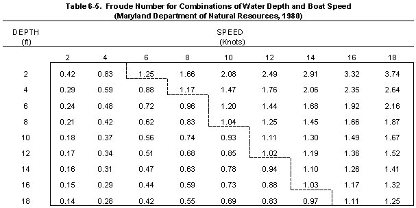
In theory, the boat speed that will produce the maximum wake depends on the depth of the water and the speed of the boat (Johnson, 1957). The ratio of these variables is called the Froude Number, named after an early scientific investigator of fluid mechanics. As the Froude Number (F) approaches 1, the wakes produced by a boat will reach their maximum value. The relationship between the Froude Number, the boat speed, and the basin depth is described by the following equation (Johnson, 1957):
where:
- Vs = Velocity of boat speed (knots)
g = Gravity constant (ft/sec2)
d = Basin depth (ft)
It is important to note that this equation can be used only to describe the boat speed at which a maximum wake will occur in water of a known depth. The equation cannot be used to calculate the actual height of the maximum wake.
Table 6-5 contains values for F calculated for different combinations of boat speed and water depth, prepared as part of a study of wakes produced by recreational boating traffic on the Chesapeake Bay in Maryland (Maryland Department of Natural Resources, 1980). The dotted line drawn through this table shows those combinations for which F approximately equals 1. For instance, boats traveling 6 to 8 knots can be expected to produce their maximum wake in water depths of 4 to 6 feet, while boats traveling 10 to 12 knots can be expected to produce their maximum wake in water depths of 12 feet. These depths are typical of conditions in small creeks and coves in coastal areas where there is generally the greatest concern about shore erosion resulting from recreational motorboat traffic.
Table 6-5 was verified with field data collected in a shallow creek in Maryland's Chesapeake Bay for two types of motorboats. The results are presented in Figure 6-23. As predicted from Table 6-5, maximum wake heights were produced at speeds ranging from 6 to 8 knots. Wake heights did not increase with increasing speed.
These results show that boats can be expected to still produce damaging wakes as they slow from high speed to enter a narrow creek or cove with a posted 6-knot limit. Locating the speed reduction zones in open water, so that boats are slowing through the critical range of velocities far from shore, would reduce the potential for shore erosion from boat wakes. The designation of no-wake zones, rather than posted speed limits, would also reduce the potential for shore erosion from boat wakes.
A recent report, Managing Coastal Erosion (NRC, 1990), summarizes the experience of coastal States in the implementation and administration of regulatory setback programs. The NRC report also discusses "the taking issue," which views setbacks as a severe restriction on the rights of private landowners to fill or build in designated setback areas. Setback regulations implemented in some States have been challenged in the courts on the grounds of "the taking issue," i.e., that the setback requirements are so restrictive that they "take" the value of the property without providing compensation to the property owners, violating the Fifth Amendment to the U.S. Constitution. The courts, however, have provided general approval of floodplain and wetlands regulations, and the NRC report concludes: "there is a strong legal basis for the broader use of setbacks for coastal construction based on the best available scientific estimates of future erosion rates."
Table 6-6 contains a summary of State programs and experiences with setbacks. In most cases, States have used the local unit of government to administer the program on either a mandatory or voluntary basis. This allows local government to retain control of its land use activities and to exceed the minimum State requirements if this is deemed desirable (NRC, 1990).
Web Note: Table 6-6 is unavailable in the web version.
Technical standards for defining and delineating setbacks also vary from State to State. One approach is to establish setback requirements for any "high hazard area" eroding at greater than 1 foot per year. Another approach is to establish setback requirements along all erodible shores because even a small amount of erosion can threaten homes constructed too close to the streambank or shoreline. Several States have general setback requirements that, while not based on erosion hazards, have the effect of limiting construction near the streambank or shoreline.
The basis for variations in setback regulations between States seems to be based on several factors, including (NRC, 1990):
- The language of the law being enacted;
- The geomorphology of the coast;
- The result of discretionary decisions;
- The years of protection afforded by the setback; and
- Other variables decided at the local level of government.
The best NPS benefits are provided by setbacks that not only include restrictions on new construction along the shore but also contain additional provisions aimed at preserving and protecting coastal features such as beaches, wetlands, and riparian forests. This approach promotes the natural infiltration of surface water runoff before it passes over the edge of the bank or bluff and flows directly into the coastal waterbody. This approach also helps protect zones of naturally occurring vegetation growing along the shore. As discussed in the section on "bioengineering practices," the presence of undisturbed shoreline vegetation itself can help to control erosion by removing excess water from the bank and by anchoring the individual soil particles of the substrate.
Almost all States with setback regulations have modified their original programs to improve effectiveness or correct unforeseen problems (NRC, 1990). States' experiences have shown that procedures for updating or modifying the setback width need to be included in the regulations. For instance, application of a typical 30-year setback standard in an area whose rate of erosion is 2 feet per year results in the designation of a setback width of 60 feet. This width may not be sufficient to protect the beaches, wetlands, or riparian forests whose presence improves the ability of the streambank or shoreline to respond to severe wave and flood conditions, or to high levels of surface water runoff during extreme precipitation events. A setback standard based on the landward edge of streambank or shoreline vegetation is one alternative that has been considered (NRC, 1990; Davis, 1987).
From the standpoint of NPS pollution control, the approach that best designates coastal wetlands, beaches, or riparian forests as a special protective feature, allows no development on the feature, and measures the setback from the landward side of the feature is recommended (NRC, 1990). In some cases, provisions for soil bioengineering, marsh creation, beach nourishment, or engineering structures may also be appropriate since the special protective features within the designated setbacks can continue to be threatened by uncontrolled erosion of the shoreline or streambank. Finally, setback regulations should recognize that some special features of the streambank or shoreline will change position. For instance, beaches and wetlands can be expected to migrate landward if water levels continue to rise as a result of global warming. Alternatives for managing these situations include flexible criteria for designating setbacks, vigorous maintenance of beaches and other special features within the setback area, and frequent monitoring of the rate of streambank or shoreline erosion and corresponding adjustment of the setback area.
5. Costs for All Practices
This section describes costs for representative activities that would be undertaken in support of one or more of the practices listed under this management measure. The description of the costs is grouped into the following three categories: (1) costs for streambank and shoreline stabilization with vegetation; (2) costs for streambank and shoreline stabilization with engineering structures; and (3) costs for designation and enforcement of boating speed limits.
a. Vegetative Stabilization for Shorelines and Streambanks
Representative costs for this practice can include costs for wetland plants and riparian area vegetation, including trees and shrubs. Additional costs could be incurred depending on the level of site preparation that is required. The items of work could include (1) clearing the site of fallen trees and debris; (2) extensive site work requiring heavy construction equipment; (3) application of seed stock or sprigging of nursery-reared plants; (4) application of fertilizer (most typically for marsh creation); and (5) postproject maintenance and monitoring. For a more extensive description of these tasks, refer to the sections of Chapter 7 describing marsh restoration efforts.
- Costs reported in 1989 for bottomland forest plants using direct seeding
were $40 to $60 per acre (NRC, 1991). If vegetation is assumed to be planted
across a 50-foot width along the shoreline or streambank, the cost per linear foot
of shore or streambank, in 1990 dollars, can be calculated as $0.05 -
$0.08/foot.
- Costs reported in 1990 for nursery-reared tree seedlings were $212.50 per
acre (Illinois Department of Conservation, 1990). If vegetation is assumed to be
planted across a 50-foot width along the shoreline or streambank, the costs per
linear foot of shore or streambank, in 1990 dollars, can be calculated as
$0.25/foot.
- Costs reported for restoration of riparian areas in Utah between 1985 and
1988 included extensive site work: bank grading, installation of riprap and
sediment traps in deep gullies, planting of juniper trees and willows, and fencing
to protect the sites from intrusion by livestock. Assuming a 100-foot width along
the shore or streambank for this work, the reported costs, in 1990 dollars, of
$2,527 per acre can be calculated as $5.94 per foot.
- Costs were reported in 1988 for vegetative erosion control projects involving
creation of tidal fringe marsh, using nursery-reared Spartina alterniflora
and S. patens along the shorelines of the Chesapeake Bay in Maryland
(Maryland Eastern Shore Resource Conservation and Development Area). Two
projects involving marsh creation along a total of 4,650 linear feet of shoreline
averaged $20.48 per foot. Costs of 12 projects involving marsh creation
combined with grading and seeding of the shoreline bank ranging in height from
5 to 12 feet averaged $54.82 per foot along a total of 8,465 feet. These costs can
be calculated in 1990 dollars as:
- Marsh creation - no bank grading . . . . . . . . . . . . . . . . . $21.44 per foot
- Marsh creation - bank grading . . . . . . . . . . . . . . . . . . . $57.40 per foot
b. Structural Stabilization for Shorelines and Streambanks
Representative costs for structural stabilization typically include costs for survey and design and for extensive site work, including costs to gain access for trucks and front-end loaders necessary to place the stone (for revetments) or sheet pile (for bulkheads). As indicated in the data described below for specific projects, costs frequently vary depending on the level of wave exposure at the site and on the overall length of shoreline or streambank that is being protected in a single project. In some of the examples shown below, construction costs were reported along with design and administration costs. For cases where only installation costs were reported in the source document, a total project cost was computed by adding 15 percent of first construction costs to the reported installation cost, and then dividing by the reported project length to compute cost per foot. Thus, all costs shown below include design and administration costs.
- Costs for timber bulkhead on private property along 100 linear feet of shore on
Cabin Creek, York County, Virginia
(less than 2 miles of wave exposure), in 1990 dollars, were $69 per foot (Virginia
Department of Conservation and
Recreation, undated).
- Costs for replacement of timber bulkhead on private property along 375 linear feet
of shore on the Rappahannock River,
Middlesex County, Virginia (2 to 5 miles of wave exposure), in 1990 dollars, were $60
per foot (Virginia Department of
Conservation and Recreation, undated).
- Costs for timber bulkhead at Whidbey Island Naval Air Station, Oak Harbor,
Washington (more than 5 miles of wave
exposure), in 1990 dollars, were $129 per foot (USACE, 1981a).
- Costs for timber and steel bulkhead along 200 feet of shoreline of a County park at
Port Wing, Bayfield County,
Wisconsin (more than 5 miles of exposure), in 1990 dollars, were $356 per foot
(USACE, 1981a).
- Costs for stone revetment on private property along 270 feet of shoreline on
Linkhorn Bay, Virginia Beach, Virginia
(less than 2 miles of wave exposure), in 1990 dollars, were $63 per foot (Virginia
Department of Conservation and
Recreation, undated).
- Costs for stone revetment and bank grading along 420 linear feet of shoreline on
James River, Surry County, Virginia
(2 to 5 miles of exposure), in 1990 dollars, were $342 per foot (Virginia Department of
Conservation and Recreation,
undated).
- Costs for stone revetment on private community property along 2000 linear feet of
shoreline on Lorain Harbor, Ohio
(more than 5 miles of exposure), in 1990 dollars, were $1,093 per foot (USACE,
1981b).
- Costs for beachfill and dune construction on a city public beach along 10,000 feet
of shoreline at North Nantasket Beach,
Hull, Massachusetts (more than 5 miles of exposure), in 1990 dollars, were $162 per
foot (USACE, 1988).
- Costs for six riprap and six gabion breakwaters with beachfill on State Wildlife
Management Area property along 1250
linear feet of shore on the James River, Surry County, Virginia (2 to 5 miles of
exposure), in 1990 dollars, were $62 per foot
(Hardaway et al., 1991).
- Costs for breakwaters, beachfill, and beachgrass planting at a County park along
1100 feet of shoreline at Elm's Beach,
Chesapeake Bay, Maryland (more than 5 miles of exposure), in 1990 dollars, were
$292 per foot (Hardaway and Gunn,
1991).
- Costs for breakwaters, beachfill, and revetment along 11,000 feet of shoreline at
Maumee Bay State Park, Ohio (more
than 5 miles of exposure), in 1990 dollars, were $961 per foot (USACE, 1982).
c. Designation and Enforcement of Boating Speed Limits
Representative costs for this practice can be broken down into the following two tasks:
- Providing notification of a posted speed limit or "no-wake" zone in navigational
channels along coastal waterways.
One approach used to advise boaters of posted speed limits is the placement of
marked buoys along the channel in speed
reduction zones. Alternatively, signs designating speed reduction zones can be placed
on pilings that are driven into the
bottom of the coastal creek or bay. In narrow creeks or coves, signs can be mounted
onshore along the streambank. The
number of signs, buoys, or beacons that will be required will depend on the length and
configuration of the channel. For a
channel 1 mile in length that is fairly straight and linear, with good visibility on both the
downstream and upstream
approaches, three posted speed limit signs could be deployed for upstream traffic and
three for downstream traffic.
Representative costs for this practice, in 1990 dollars, can be estimated from data
provided by the Maryland Department
of Natural Resources Marine Police Administration. These costs include all labor,
materials, and installation:
- Costs for purchasing, marking, and setting six buoys at $285 each are $1,710.
- Costs for six onshore signs mounted on 2-ft by 3-ft by 8-ft posts at $165 each are $990.
- Costs for six channel beacons mounted on offshore 4-ft by 4-ft by 42-ft pilings at $1,850 each are $11,100.
- The enforcement of designated boating speed limit zones, which can be expected
to include costs for the acquisition and
maintenance of marine police vessels and costs for marine police personnel to monitor
boating patterns. Representative
costs, in 1990 dollars, which are incurred for these items by the Maryland Department
of Natural Resources (Gwynne
Schultz, personal communication, 1992) are listed below:
- One large patrol boat (suitable for areas of open water in coastal bays or
rivers):
- Acquisition $180,000
- Annual maintenance per vessel per year $ 2,000
- Crew of three marine police $ 90,000
- One small patrol boat (suitable for protected creeks and coves):
- Acquisition $20,000
- Annual maintenance per vessel per year $ 2,000
- Crew of two marine police $60,000
- One large patrol boat (suitable for areas of open water in coastal bays or
rivers):
These costs do not consider overtime that is provided to members of the Maryland Marine Police for any shift greater than 8 hours in length. No overtime is paid for holidays.
Continue to Next Section
Return to the Table of Contents
This page last updated October 4, 1999