
C. Road Construction/Reconstruction Management Measure
- Follow preharvest planning (as described under Management Measure A) when constructing or reconstructing the roadway.
- Follow designs planned under Management Measure A for road surfacing and shaping.
- Install road drainage structures according to designs planned under Management Measure A and regional storm return period and installation specifications. Match these drainage structures with terrain features and with road surface and prism designs.
- Guard against the production of sediment when installing stream crossings.
- Protect surface waters from slash and debris material from roadway clearing.
- Use straw bales, silt fences, mulching, or other favorable practices on disturbed soils on unstable cuts, fills, etc.
- Avoid constructing new roads in SMAs to the extent practicable.
1. Applicability
This management measure is intended for application by States on lands where silvicultural or forestry operations are planned or conducted. It is intended to apply to road construction/reconstruction operations for silvicultural purposes, including:
- The clearing phase: clearing to remove trees and woody vegetation from the road right-of-way;
- The pioneering phase: excavating and filling the slope to establish the road centerline and approximate grade;
- The construction phase: final grade and road prism construction and bridge, culvert, and road drainage installation; and
- The surfacing phase: placement and compaction of the roadbed, road fill compaction, and surface placement and compaction (if applicable).
2. Description
The goal of this management measure is to minimize delivery of sediment to surface waters during road construction/reconstruction projects. Figure 3-15 depicts various road structures addressed by this management measure. Disturbance of soil and rock during road construction/reconstruction creates a significant potential for erosion and sedimentation of nearby streams and coastal waters. Some roads are temporary or seasonal-use roads, and their construction does not involve the high level of disturbance generated by permanent, high-standard roads. However, temporary or low-standard roads still need to be constructed in such a way as to prevent disturbance and sedimentation. Brown (1972) stated that road construction is the largest source of silviculture-produced sediment in the Pacific Northwest. It is also a significant source in other regions of the country. Therefore, proper road and drainage crossing construction practices are necessary to minimize sediment delivery to surface waters. Proper road design and construction can prevent road fill and road backslope failure, which can result in mass movements and severe sedimentation. Proper road drainage prevents concentration of water on road surfaces, thereby preventing road saturation that can lead to rutting, road slumping, and channel washout (Dyrness, 1967; Golden et al., 1984). Proper road drainage during logging operations is especially important because that is the time when erosion is greatly accelerated by continuous road use (Kochenderfer, 1970). Figure 3-16 presents various erosion and sediment control practices.Surface protection of the roadbed and cut-and-fill slopes can:
- Minimize soil losses during storms;
- Reduce frost heave erosion production;
- Restrain downslope movement of soil slumps; and
- Minimize erosion from softened roadbeds (Swift, 1984).
3. Management Measure Selection
Most erosion from road construction occurs within a few years of disturbance (Megahan, 1980). Therefore, erosion control practices that provide immediate results (such as mulching or hay bales) should be applied as soon as possible to minimize potential erosion (Megahan, 1980). King (1984) found that the amount of sediment produced by road construction was directly related to the percent of the area taken by roads, the amount of protection given to the seeded slopes, and whether the road is given a protective surface (Table 3-21).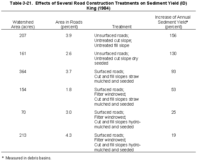
a. Effectiveness Information
The effectiveness of road surfacing in controlling erosion was demonstrated by Kochenderfer and Helvey (1984)(Table 3-22). The data show that using 1-inch crusher-run gravel or 3-inch clean gravel can reduce erosion to less than one-half that of using 3-inch crusher run gravel and to 12 percent that of an ungraveled road surface.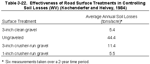
According to Swift (1984b), road cuts and fills are the largest source of sediment once a logging road is constructed. His research showed that planting grass on cut-and-fill slopes of new roads effectively reduced erosion in the southern Appalachians. The combined effectiveness of grass establishment and roadbed graveling was a 97-99 percent reduction in soil loss.
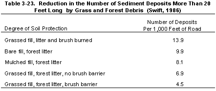
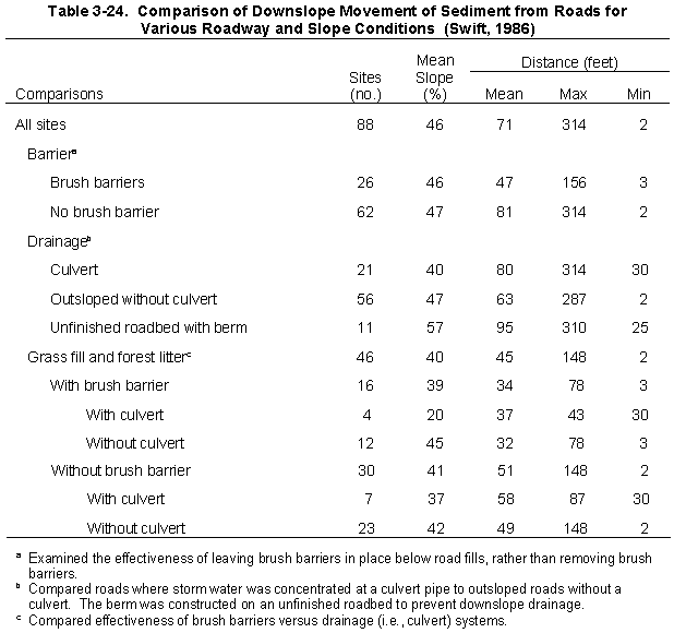
Swift (1986) measured the extent of downslope soil movement for various categories of roadway and slope conditions (Tables 3-23 and 3-24). He found that grassed fill was more effective than mulched fill or bare fill in reducing the downslope movement of soil from newly constructed roads. The author determined grass, forest floor litter, and brush barriers to be effective management practices for reducing downslope sediment.
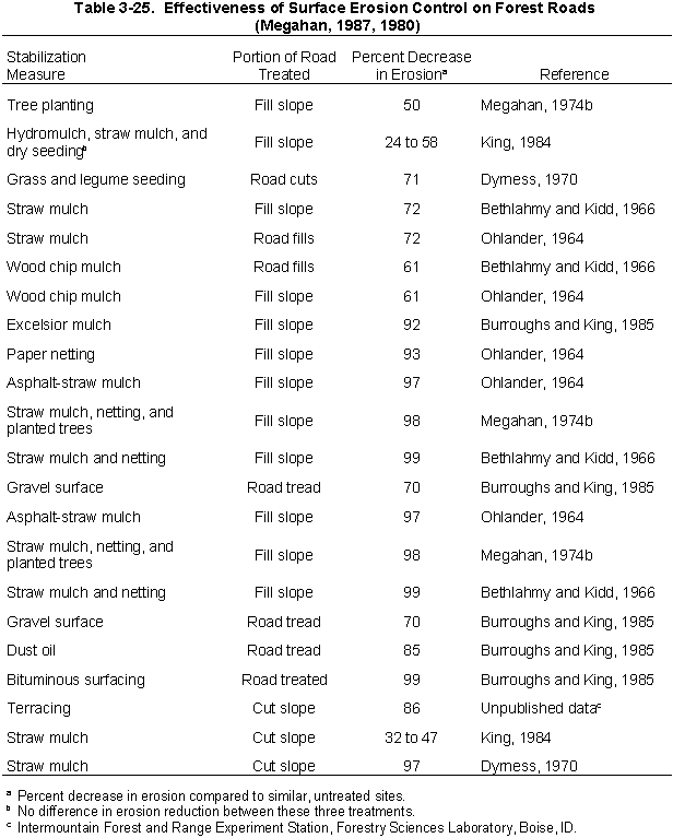
Megahan (1980, 1987) summarized the results of several studies that echo Swift's conclusions (Table 3-25 (14k)). The combination of straw mulch with some type of netting to hold it in place reduces erosion by more than 90 percent and has the added benefits of providing immediate erosion control and promoting revegetation. Treating the road surface reduced erosion 70 to 99 percent. Grass seeding alone can control erosion in moist climates, as confirmed by Swift (1984b).
b. Cost Information
The costs associated with construction of rolling dips on roads were estimated by Dubensky (1991) as $19.75 each, with more dips needed as the slope of the road increases.Ellefson and Miles (1984) determined the decline in net revenue associated with culvert construction, water bar construction, and construction of broad-based dips to be 3.8 percent, 2.3 percent, and 2.4 percent, respectively, for a timber sale with net revenue of $124,340 without these practices. Kochenderfer and Wendel (1980) examined road costs, including bulldozing, construction of drainage dips, culvert installation, and graveling. They concluded that:
- Cost to reconstruct a road (including 600 tons of 3-inch clean stone surfacing
at
$5.74/ton) = $5,855 per
mile. Cost also included 20.5 hours (25 hours/mile) of D-6 tractor time (for road
construction and construction
of broad-based drainage dips), 23 hours (28 hours/mile) of JD 450 tractor time to
spread
gravel and do final dip
shaping, and installation of two culverts. Road construction without the stone would
have
cost
$1,061/mile.
- Cost for a newly constructed road was $3,673 per mile, including 200 tons of
gravel. Costs included
46.5 hours (57 hours/mile) of D-6 tractor time to bulldoze the road and construct 22
drainage
dips. Spreading gravel
and final dip shaping required 7.5 hours of JD tractor time. This road, constructed
without
stone, would have cost
$2,078 per mile.
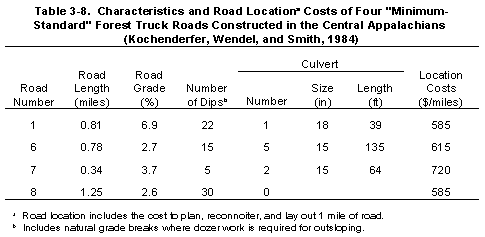
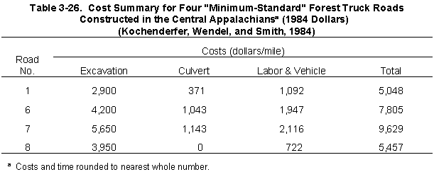
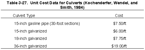
Kochenderfer, Wendel, and Smith (1984) examined the costs associated with road construction of four minimum standard roads in the Appalachians (Table 3-8 gives road characteristics). Excavation costs varied according to site-specific factors (soil type, rock outcrop extent, topography) and increased as the amount of rock needing blasting and the number of large trees to be removed increased. Culvert costs varied according to the size and type of culvert used (Tables 3-26 and 3-27).
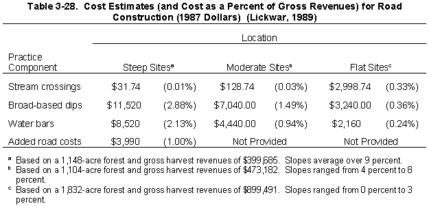
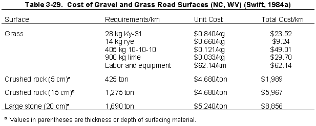
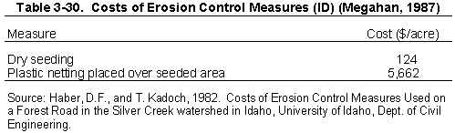
Lickwar (1989) studied the costs of various forestry practices in the Southeast. He determined that practices associated with road construction were generally the most expensive, regardless of terrain. The costs for broad-based dips and water bars increased as the terrain steepened, indicating increased implementation of erosion and runoff control practices as slopes increased (Table 3-28). Steeper areas also required additional (nonspecified) road costs that were not necessary in moderate to flat areas. Unit cost comparisons for surfacing practices (Swift, 1984a) reveal that grass is the least expensive alternative, at $174 per kilometer of road (Table 3-29). Five-centimeter crushed rock cost almost $2000 per kilometer, 15-centimeter gravel cost about $6000, and 20-centimeter gravel cost almost $9000. The author cautions, however, that material costs alone are misleading because an adequate road surface might endure several years of use, whereas a grassed or thinly-graveled surface would need replenishing. Even so, multiple grass plantings may be cheaper and more effective than gravel spread thinly over the roadbed, depending on climate, growing conditions, soil type, and road use (Swift, 1984b). Megahan (1987) found that dry seeding alone cost significantly less than seeding in conjunction with plastic netting (Table 3-30).
4. Practices
As discussed more fully at the beginning of this chapter and in Chapter 1, the following practices are described for illustrative purposes only. State programs need not require implementation of these practices. However, as a practical matter, EPA anticipates that the management measure set forth above generally will be implemented by applying one or more management practices appropriate to the source, location, and climate. The practices set forth below have been found by EPA to be representative of the types of practices that can be applied successfully to achieve the management measure described above.
Slash can be useful if placed as windrows along the base of the fill slope. Right-of-way material that is merchantable can also be used by the operator.
- Broad-based Dip Construction. A broad-based dip is a gentle roll in
the
centerline profile of a
road that is designed to be a relatively permanent and self-maintaining water diversion
structure and can be traversed
by any vehicle (Swift, 1985, 1988) (See Figure 3-17). The dip should be outsloped 3
percent
to divert stormwater
off the roadbed and onto the forest floor, where transported soil can be trapped by
forest litter
(Swift, 1988). Broad-based dips should be used on roads having a gradient of 10
percent or
less. Proper construction requires an
experienced bulldozer operator (Kochenderfer, 1970).
- Installation of Pole Culverts and/or Ditch Relief Culverts. Culverts are
placed at
varying intervals
in a road to safely conduct water from the ditch to the outside portion of the road.
Figures
3-18 and 3-19 highlight
the design and installation of pole and pipe culverts, respectively. Culverts often need
outlet
and inlet protection to
keep water from scouring away supporting material and to keep debris from plugging
the
culvert. Energy dissipators,
such as riprap and slash, should be installed at culvert outlets (Rothwell, 1978).
Culvert
spacing depends on rainfall
intensity, soil type, and road grade. Culvert size selection should be based on drainage
area
size and should be able
to handle large flows. Open-top or pole culverts are temporary drainage structures that
are
most useful for
intercepting runoff flowing down road surfaces (Kochenderfer, 1970). They can also be
used
as a substitute for pipe
culverts on roads of smaller operations, if properly built and maintained, but they
should not
be used for handling
intermittent or live streams. Open-top culverts should be placed at angles across a
road to
provide gradient to the
culvert and to ensure that no two wheels of a vehicle hit the ditch at once.
- Road Outsloping and Grading. Grade and outslope roadbeds to minimize
water
accumulation on road
surfaces (Kochenderfer, 1970). This practice minimizes erosion and road failure
potential.
Outsloping involves
grading the road so that it slopes downward from the toe of the road cut to the
shoulder. The
slope should be about
3-4 percent (Rothwell, 1978). Outsloping the roadbed keeps water from flowing next to
and
undermining the cut
bank, and is intended to spill water off the road in small volumes at many random sites.
In
addition to outsloping the
roadbed, a short reverse grade should be constructed to turn water off the surface.
Providing
a berm on the outside
edge of an outsloped road during construction, and until loose fill material is protected
by
vegetation, can eliminate
fill erosion (Swift, 1985). The effectiveness of outsloping is limited by roadbed rutting
during
wet conditions. Also,
berms may form along the edge of older roadbeds and block drainage (Swift, 1985).
Therefore, proper maintenance
of these structures is necessary.
- Ditch and Turnout Construction. Ditches should be used only where necessary and should discharge water into vegetated areas through the use of turnouts. The less water ditches carry and the more frequently water is discharged, the better. Construct wide, gently sloping ditches, especially in areas with highly erodible soils. Ditches should be stabilized with rock and/or vegetation (Yoho, 1980) and outfalls protected with rock, brush barriers, live vegetation, or other means. Roadside ditches should be large enough to carry runoff from moderate storms. A standard ditch used on secondary logging roads is a triangular section 45 cm deep, 90 cm wide on the roadway side, and 30 cm wide on the cut bank side. Minimum ditch gradient should be 0.5 percent, but 2 percent is preferred to ensure good drainage. Runoff should be frequently diverted into culverts to prevent erosion or overflow (Rothwell, 1978).
Methods to trap sediment include:
- Brush Barriers. Brush barriers are slash materials piled at the toe
slope of a
road or at the outlets
of culverts, turnouts, dips, and water bars. Brush barriers should be installed at the toe
of fills
if the fills are located
within 150 feet of a defined stream channel (Swift, 1988). Figure 3-20 shows the use of
a
brush barrier at the toe of
fill. Proper installation is important because if the brush barrier is not firmly anchored
and
embedded in the slope,
brush material may be ineffective for sediment removal and may detach to block
ditches or
culverts (Ontario Ministry
of Natural Resources, 1988). In addition to use as brush barriers, slash can be spread
over
exposed mineral soils to
reduce the impact of precipitation events and surface flow.
- Silt Fences. Silt fences are temporary barriers used to intercept sediment-
laden
runoff from small areas.
They act as a strainer: silt and sand are trapped on the surface of the fence while water
passes
through. They may
consist of woven geotextile filter fabric or straw bales. Silt fences should be installed
prior to
earthmoving operations
and should be placed as close to the contour as possible.
- Riprap. Riprap is a layer of rocks or rock fragments placed over exposed
soil to
protect it from erosive
forces. Riprap is generally used only in areas where the velocity of water flow,
seriousness of
erosion, steepness of
slope, or material type prevents satisfactory establishment of vegetation. Stones of
suitable
size are fitted and
implanted in the slope to form a contiguous cover (Figure 3-21). When used near
streams,
riprap should be extended
below the stream channel scour depth and above the high water line. Commonly, a
filter cloth
or graded filter blanket
of small gravel is laid beneath the riprap. Riprap should not be used on slopes that are
naturally subject to deep-seated
or avalanche-type slide failure. Riprap should be used in conjunction with other slope
stabilization techniques and
then only if these techniques are ineffective alone. Riprap is not recommended for very
steep
slopes or fine-grained
soils (Hynson et al., 1982).
- Filter Strips. Sediment control is achieved by providing a filter or buffer
strip
between streams and
construction activities in order to use the natural filtering capabilities of the forest floor
and
litter. The Streamside
Management Area management measure requires the presence of a filter or buffer strip
around all waterbodies.
Cutbanks and fillslopes along forest roads are often difficult to revegetate (Berglund, 1978). Properly condition slopes to provide a seedbed, including rolling of embankments and scarifying of cut slopes. The rough soil surfaces will provide niches for seeds to lodge and germinate. Seed as soon as possible after disturbance, preferably during road construction or immediately following completion and within the same season (Larse, 1971). Early grassing and spreading of brush or erosion-resisting fabrics on exposed soils at stream crossings are imperative (Swift, 1985). See the Revegetation of Disturbed Areas management measure for a more detailed discussion.
This will prevent tracking of sediment onto roadways, thereby preventing the subsequent washoff of that sediment during storm events. When necessary, clean truck wheels to remove sediment prior to entering a public right-of-way.
Avoid operating machinery in waterbodies. Work within or adjacent to live streams and water channels should not be attempted during periods of high streamflow, intense rainfall, or migratory fish spawning. Avoid channel changes and protect embankments with riprap, masonry headwalls, or other retaining structures (Larse, 1971).
If possible, culverts should be installed within the natural streambeds. The inlet should be on or below the streambed to minimize flooding upstream and to facilitate fish passage. Culverts should be firmly anchored and the earth compacted at least halfway up the side of the pipe to prevent water from leaking around it (Figure 3-22). Both ends of the culvert should protrude at least 1 foot beyond the fill (Hynson et al., 1982). Large culverts should be aligned with the natural course and gradient of the stream unless the inlet condition can be improved and the erosion potential reduced with some channel improvement (Larse, 1971). Use energy dissipators at the downstream end of the culverts to reduce the erosion energy of emerging water. Armor inlets to prevent undercutting and armor outlets to prevent erosion of fill or cut slopes.
Isolating the work site from the flow of water is necessary to minimize the release of soil into the watercourse and to ensure a satisfactory installation in a dry environment. Limit the duration of construction to minimize environmental impacts by establishing disturbance limits, equipment limitations, the operational time period when disturbance can most easily be limited, and the use of erosion and sediment controls, such as silt fences and sediment catch basins. Diversions should be used only where constructing the stream crossing structure without diverting the stream would result in instream disturbance greater than the disturbance from diverting the stream. Figure 3-23 portrays a procedure for installing a large culvert when excavation in the channel of the stream would cause sedimentation and increase turbidity.
During construction, fills or embankments are built up by gradual layering. Compact the entire surface of each layer with a tractor or other construction equipment. If the road is to be grassed, the final layer should not be compacted in order to provide an acceptable seedbed.
- Stack usable materials such as timber, pulpwood, and firewood in suitable locations and use them to the extent possible. Alternatives for use of other materials include piling and burning, chipping, scattering, windrowing, and removal to designated sites.
- Organic debris should not be used as fill material for road construction since the organic material would eventually decompose and cause fill failure (Hynson et al., 1982; Larse, 1971).
- Debris that is accidently deposited in streams during road construction should be removed before work is terminated.
- All work within the stream channel should be accomplished by hand to avoid the use of machinery in the stream and riparian zone (Hynson et al., 1982).
Pioneer roads are temporary access ways used to facilitate construction equipment access when building permanent roads.
- Confine pioneer roads to the construction limits of the surveyed permanent roadway.
- Fit the pioneer road with temporary drainage structures (Hynson et al., 1982).
Regulating traffic on logging roads during unfavorable weather is an important phase of erosion control. Construction and logging under these conditions destroy drainage structures, plug up culverts, and cause excessive rutting, thereby increasing the amount and the cost of required maintenance (Kochenderfer, 1970).
Gravel mining directly from streams causes a multitude of impacts including destruction of fish spawning sites, turbidity, and sedimentation (Hynson et al., 1982). During the construction and use of rock quarries, gravel pits, or borrow pits, runoff water should be diverted onto the forest floor or should be passed through one or more settling basins. Rock quarries, gravel pits, spoil disposal areas, and borrow pits should be revegetated and reclaimed upon abandonment.
Continue to Next Section
Return to the Table of Contents
This page last updated October 4, 1999