 |
|
|
SECTION 2 - NON-POINT SOURCE POLLUTION CONTROL PROCESSES AND PLANNING PRINCIPLES
This section is intended to provide a basic understanding of non-point source (NPS) pollution processes and the principles for minimizing or preventing their effects.. These principles must be understood in order to facilitate a comprehensive management strategy, including the design and application of techniques which can effectively control undesired consequences of urban development.
Although this manual is primarily developed to address non-point source impacts, other considerations also need to be addressed. Total natural resource planning will include components that address soil, water, air, plant, and animal resources. In addition, the human aspect of cultural, social, and economic issues needs to be considered.
While this section does not provide a complete discussion of the many issues that should be considered to develop an effective NPS pollution control plan, it does provide a general description of the following key principles and processes:
A. Overview of Non-point Sources and Impacts;
B. Planning Principles for Selecting and Implementing Best Management Practices (BMPs);
Most NPS pollution control plans will be prepared, and BMPs designed, to meet the requirements of existing ordinances or other governmental or agency regulations or codes. These requirements must be clearly understood so that planning can proceed in a timely and cost effective manner. However, considering the limited scope of many local ordinances, it is strongly recommended that NPS pollution control plans, and site designs, go beyond the required components to address resource concerns in a holistic, multi-objective manner.
References included in Section 9 that are especially useful in supplementing this section are numbers 7, 13, 14, and 17. Many or all of the other references should be added to a library for more specific or more detailed discussion of principles, processes, procedures, or practices.
This section was revised in January 1999.
NRCS IL January 1999
urbse_2.doc
A. OVERVIEW OF NONPOINT POLLUTION SOURCES AND IMPACTS
Recent reports acknowledge that a principal water quality problem in our Nation is non-point source (NPS) pollution. The U.S. Environmental Protection Agency (USEPA) defines NPS pollution as precipitation driven stormwater runoff, generated by land-based activities, such as agriculture, construction, mining, or silviculture. These activities result in diffuse runoff, seepage or percolation of pollutants from the land surface to ground and surface waters.
The Illinois Environmental Protection Agency (EPA) has documented the nature and degree of NPS pollution impacts throughout the State. Numerous watershed assessments have further documented these impacts. To put non-point sources of pollution and the need for their control into perspective, the Illinois EPA first evaluates streams, lakes, and other aquatic ecosystems with respect to their ability to support designated uses, such as aquatic life or swimming. If a use is impaired, causes are identified. Typically, a number of sources, both point and non-point, are identified as contributors. Finally, a list of appropriate BMPs is provided to control the identified non-point sources. While this manual focuses on the selection, design, and implementation of those BMPs, it is important to understand the linkage between BMPs, non-point sources, causes, and use impairments to appreciate the importance of a multi-objective management plan.
A notable distinction between the USEPA definition of non-point source pollution, cited above, and Illinois EPA's definition is the recognition that non-point sources affect not just water quality but also the physical habitat of aquatic ecosystems. The Illinois EPA identifies eight basic categories of NPS pollution which encompass agricultural, urban, and special land development activities (e.g., mining). This manual focuses on NPS pollution in the following categories:
- erosion from construction sites;
- urban runoff; and
- hydrologic/habitat modification.
Development has both direct and indirect impacts on water bodies and other valuable natural features. These impacts occur both during construction and after the development is complete. Some impacts result from the direct modification or destruction of streams, lakes, and wetlands. Other impacts occur primarily offsite due to changes in the quality and quantity of runoff from the development. Some common NPS pollution sources from development are described below.
1. Erosion from Construction Sites
Erosion and sedimentation are natural geologic processes that human activities often accelerate. Erosion occurs through the action of water or wind. In Illinois, water is the primary cause of erosion. Wind erosion in urban areas is a minor concern, but it can be a nuisance and even a safety hazard in areas near a site under development.
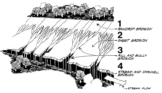
There are three major processes that must be understood to effectively control or limit soil erosion and sedimentation on construction sites. These are detachment, transport, and deposition. Four types of erosion showing detachment and transport of soil on an exposed slope are shown in Figure 2.1. The four erosion types are as follows:
Raindrop erosion is erosion resulting from the direct impact of falling drops of rain on soil particles. This impact dislodges soil particles and splashes them into the air. The dislodged soil particles can then be easily transported by the flow of surface runoff.
Sheet erosion is the removal of a layer of exposed surface soil by the action of raindrop splash and runoff. The water moves in broad sheets over the land and is not confined in small depressions.
Rill and Gully erosion occurs after runoff flows concentrate into rivulets, cutting several inches deep into the soil surface. These grooves are called rills. Gullies may develop from rills if not repaired or in other areas where a concentrated flow of water moves over the soil.
Stream and Channel erosion occurs with an increase in the volume and velocity of runoff. These larger and faster flows detach and then transport soil from the stream bottom and the stream bank toe. If not repaired, large sections of the stream bank may fail or slump into the stream.
Figure 2-1 The Four Types of Soil Erosion on an Exposed Slope
Many of the BMPs included in Section 4 of this manual will individually address one or more types of erosion. Of these, most will impact the detachment or movement of sediment or provide storage methods.
National estimates indicate that uncontrolled erosion from construction activities can generate enormous quantities of sediment -- 20 to 200 tons per acre per year. In comparison, typical erosion rates from croplands range from 1 to 20 tons per acre per year. Figure 2-2 shows a relative comparison of suspended sediment loading, again indicating the relatively high contribution of sediment from construction sites.
Relative Suspended Sediment Loads
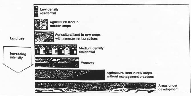
Adapted from Wisconsin Department of Natural ResourcesFigure 2-2 Sediment Losses Related to Land Use Practices
Construction site erosion and the movement of sediment as it leaves the site causes several offsite problems. Also, a site that has been degraded from excessive erosion is more expensive to landscape and maintain. The resultant sediment deposits are expensive to remove from culverts, ditches, lakes, or streams. A brief summary of environmental impacts follows.
Water quality impairment: Sediment from construction sites adversely affects water clarity, which reduces sunlight penetration thereby limiting photosynthesis by aquatic plants. In addition, impaired water clarity negatively impacts fish searching for their prey. Sediment-laden runoff also transfers nutrients and other pollutants to downstream lakes and rivers, degrades habitats and spawning areas of aquatic organisms, and increases costs for water treatment.
Loss of flood conveyance and storage: Excess sediment from construction sites fills storm sewers and ditches, detention basins, wetlands, and stream and river channels. This sediment must be removed to maintain the flow or storage capacity. If not removed, this accumulated sediment worsens drainage and flooding problems and can limit the navigability of river channels. In addition, increased rates of runoff from construction sites can cause local flooding problems.
Degradation of natural areas: Over time, sediment accumulation can lead to the degradation of natural plant communities, such as prairies and wetlands. Sediment accumulation has several negative effects on natural communities. The sediment can bury or suffocate existing plants, smother the native seed bank present, and can act as a medium for the germination of exotic plant seeds that were carried in with the sediment. Many of the exotic species are aggressive (e.g., purple loosestrife, reed canary grass) and can eliminate other more desirable species within a short period of time.
Safety and nuisance problems: Sediment on roadways, conveyed either by direct runoff from construction sites or tracking by construction vehicles, can be a traffic safety hazard. Dust generated from unprotected soil on uncontrolled construction sites is a nuisance for adjacent property owners.
Urban runoff has been sampled at numerous locations in Illinois and around the country. These data show that urban runoff is contaminated with a number of pollutants, including sediment, heavy metals, petroleum-based hydrocarbons, nutrients, pesticides, chlorides, bacteria, and oxygen-demanding organic matter. It is becoming apparent that pollution in urban runoff is more damaging to many water bodies and ecosystems than pollution from municipal and industrial treatment plants, known as point sources.
Much of the pollutant load is generated from impervious surfaces, particularly roadways and parking lots, and is related to automobile traffic. It is not surprising, therefore, that high density development activities, such as commercial, industrial, and highway projects, generally contribute higher pollutant loads than lower density residential developments. Another important factor controlling the level of pollutant runoff from urban areas is the opportunity for natural vegetative filtering on the site. Unfortunately, most modern developments route runoff from impervious surfaces directly into storm sewers or paved channels which effectively convey the pollutants, without any opportunity for infiltration or filtering, into receiving water bodies.
Water quality impacts of urban runoff have been extensively documented around the country. The following are some common impacts noted in Illinois:.
Nutrient enrichment/eutrophication: Pollutant loads of phosphorus and nitrogen in urban runoff are substantially higher than in runoff from undeveloped lands. Most nutrients applied in the urban setting are used on lawns, golf courses and other intensively used and maintained landscapes. Nutrients either move with the water, like nitrogen, or are attached to eroded soil, like phosphorous. High nutrient levels in lakes and slow moving rivers can result in excessive growth of algae and other aquatic plants which can impair aesthetics, water quality, and recreational potential.
Toxicity to aquatic life: Urban runoff pollutant concentrations often exceed water quality standards. Potential toxicants include pesticides, other organic compounds, and heavy metals. Such toxicants can move with the water, in the air, attached to soil particles, or in plants and animals depending on their solubility in water, origin, mode of application, and other chemical and physical properties. While existing data are not conclusive in showing that these pollutants occur in water bodies in concentrations which are acutely toxic to aquatic biota, there is evidence to indicate that adverse impacts may result from chronic exposure and bioaccumulation of pollutants in the tissue of sensitive organisms. Factors that may worsen toxicity effects include high water temperature (discussed below) and low dissolved oxygen. Dissolved oxygen may be reduced to dangerous levels due to the decomposition of organic matter that is washed off of urban land surfaces by storm events, particularly during the summer time. Low dissolved oxygen also may be a problem during winter ice-cover conditions due to the oxygen demand of contaminated sediments and decaying plant matter. Fish kills are common in urban lakes and detention ponds as a result of such factors.
Sediment contamination: The bottom substrates of water bodies in urban areas are typically coated with a layer of contaminated sediment resulting from urban runoff. This sediment may interfere with the reproduction and feeding mechanisms of aquatic organisms, including fish. It also may be toxic to some sensitive organisms due to elevated concentrations of pesticides, heavy metals, and petroleum-based organic compounds. Urban runoff sediments may also have a relatively high organic content that exerts an oxygen demand as it is "broken down" in receiving water bodies.
Bacterial contamination: The water quality standard for fecal coliform bacteria is frequently violated in urban water bodies following storm events. The violation of this standard generally reflects the presence of significant animal or human waste in the water, and is commonly used as an indicator for the closing of swimming beaches. Additional tests are typically needed to verify whether the contamination is of human origin, such as from faulty septic systems or illicit connections between sanitary sewers and storm sewers.
Salt contamination: The use of salt as a deicing agent can result in extremely high salinity levels in roadside ditches and downstream water bodies. While salinity levels are typically not high enough to be acutely toxic to fish and other aquatic organisms, they may adversely impact sensitive plant communities, particularly wetland species. Further, salt and other soluble urban runoff constituents can degrade aquifers used as a source of water supply.
Impaired aesthetic conditions: Urban runoff carries a number of constituents that may impair the visual appeal and clarity of receiving water bodies. These constituents, including trash and debris, suspended solids, and oil and grease, reduce the recreational potential of many urbanwater bodies in urban areas.
Elevated water temperatures: Watershed urbanization has been shown to significantly increase summertime temperatures in receiving streams. This effect is due to a number of factors, including the removal of natural shading and the reduction of base flows, as discussed below. Runoff from impervious surfaces that have been heated by the sun also contributes to this effect. The resultant elevated water temperatures are directly stressful to native aquatic life and increases water quality problems.
Impairment of water supplies: Many of the contaminants listed above adversely affect both surface and groundwater sources of water supply. While surface water impacts can be directly determined from existing data, it is much more difficult to assess the effects to groundwater because of the complexity of multiple sources and routes into underground aquifers.
Beyond their effects on runoff quality, development activities invariably alter runoff patterns by converting pervious land to impervious surfaces and compacting remaining pervious surfaces (e.g., lawns). This conversion results in dramatic increases in the rate and volume of storm runoff and reductions in groundwater recharge. Also, urban drainage features such as storm sewers and lined channels convey runoff water downstream at a much faster rate. This leads to a number of consequences, several of which are explained below.
Increased flooding: Flood flow rates have been shown to increase by 100 to 200 percent or more if a watershed is urbanized without effective stormwater detention. Local drainage problems also are made more severe. As a result, flood damages may be sustained by downstream residences and businesses, and government officials may be forced to implement expensive remedial projects.
Stream channel erosion: Increased rates of runoff and resultant high channel velocities can destabilize downstream channels leading to excessive bank erosion and/or downcutting of the channel, often threatening adjacent structures. This problem is common in Illinois streams, particularly where alterations have been made to the stream or watershed.
Hydrologic destabilization: Development generally results in higher, and more frequent storm flows, and lower and longer duration low flows. The more frequent high flows and the high velocities that accompany them can sometimes "flush out" natural substrates and bottom dwelling organisms. The lower low flows tend to concentrate stream pollutants and reduce stream depths necessary for the survival of fish. Extended low flows also can result in higher summertime water temperatures that further stress fish and other aquatic organisms. Reduced recharge rates can also result in lower water levels in lakes and wetlands during critical dry periods.
3. Hydrologic/Habitat Modification
Some urban developments directly impact sensitive water bodies and wetlands. To accommodate development plans, streams are sometimes channelized or rerouted. Wetlands may be filled, excavated, or drained. More subtle forms of modification include the removal of native vegetation from stream banks and lakeshores. These activities not only destroy critical aquatic habitats, they also impair other valuable functions. These impacts are summarized below.
Destruction of aquatic and terrestrial habitat: Draining, straightening, vegetation removal, filling, and dredging of natural water bodies and wetlands adversely affects habitat for water dependent fish, wildlife, and waterfowl. In addition to short-term effects caused by construction, significant long-term effects often result due to the elimination of spawning and breeding areas, cover, shading, and a general reduction in habitat diversity. Often, the result of construction in a water body or wetland is the replacement of native vegetation with man-made structures such as riprap or metal retaining walls. Such man-made structures typically do not address the habitat needs of resident aquatic life and wildlife.
Water quality impairment: Construction in and adjacent to water bodies and wetlands create both long-term and short-term effects on water quality. The primary short-term effect is erosion, which was discussed previously. However, the consequences of construction in water bodies and wetlands are often much more severe than construction in upland locations because of the erosive effects of flowing water and wave action. The long-term effects of development in water bodies and wetlands relate primarily to the elimination of vegetation and other natural materials. The typical consequences of these alterations include reduced shading and a resultant increase in water temperature, reduced capacity for pollutant filtering, and an increased propensity for instability and erosion.
Alteration of natural storage and conveyance functions: While state and federal regulations place some constraints on the degree of alteration allowed in floodplains and wetlands, there may still be significant adverse impacts on natural stormwater storage and conveyance functions. Typical consequences include the reduction in stream roughness (or flow retardance) and length due to channel modifications and loss of stormwater storage due to draining or filling of small wetlands. This results in increased flow velocities and volumes, which cause stream channel erosion and increased flooding.
The ultimate concern regarding non-point sources is whether they impair the desired uses of water bodies and aquatic ecosystems -- particularly aquatic life, swimming, and water supply uses. There now is clear evidence from Illinois and around the country that watershed urbanization has serious adverse impacts on the beneficial uses of downstream water bodies. In northeastern Illinois, an analysis of data from over forty streams and rivers showed that virtually all streams with urban or suburban watersheds had degraded fish communities (i.e., fair to poor conditions based on the Index of Biotic Integrity). In contrast, nearly all streams in rural/agricultural watersheds had good to excellent fish communities. While this correlation may not apply statewide, it does indicate the need to better control urban non-point source impacts to avoid the otherwise inevitable degradation of receiving water bodies.
B. PLANNING PRINCIPLES FOR SELECTING AND IMPLEMENTING BEST MANAGEMENT PRACTICES
Planning principles are the overall guidelines that need to be considered to develop and implement a non-point source control plan that will survive the test of time and provide ecologically and economically sustainable development, while meeting the needs of society. The basic planning principles listed below apply both to new developments as well as existing sites in need of remedial BMPs.
- Thoroughly collect, review and understand all existing local, state, federal governmental or agency rules, regulations, restrictions, codes, permits, etc.
- Determine who can help you develop a plan that meets your needs and addresses identified resource concerns.
- Thoroughly document the pre-development characteristics of the site and immediate surroundings, focusing particularly on topography, drainage patterns, soils, and the presence of important natural features such as streams, water bodies, wetlands, woodlands, and natural area remnants.
- Plan the development or remedial project to fit the particular topography, soil, drainage patterns and natural vegetation of the site.
Application of these planning principles is particularly important for new developments. Good site planning is often the key to minimizing adverse environmental impacts. Effective site planning and design will result in minimal impacts to water quality, natural hydrologic characteristics, and sensitive landscape features. Site design and the application of sound planning principles are critical factors in achieving effective soil erosion and sediment control, stormwater management, and protection of stream, lake, and wetland resources as described below.
C. PLANNING PRINCIPLES FOR SOIL EROSION AND SEDIMENT CONTROL
This manual describes BMPs to accomplish three basic elements of erosion and sediment control:
- Soil stabilization;
- Runoff control; and
- Sediment control.
The most important, and most often neglected,, task is to provide effective soil stabilization throughout the duration of a construction project. Soil stabilization is based on a simple premise:. If water cannot detach the soil, it cannot be transported (i.e., erosion does not occur). The easiest, most economical, and environmentally sound way to prevent detachment is by keeping a good vegetative cover in place. It also can be accomplished via other techniques such as mulching or use of erosion blankets.
Runoff control measures are needed to deal with concentrated runoff. Concentrated runoff is a common occurrence on large sites containing existing drainageways and is made more severe by grading activities that removes water absorbent topsoil and compact underlying soils. If concentrated runoff occurs, it will further erode the soil and carry it into streams, lakes, or road ditches. The basic principles behind runoff control measures are to provide stabilized channels for runoff water and to divert concentrated runoff from exposed, erodible soils.
Once the soil is detached, flowing water transports the soil to downslope positions. Sediment control measures are needed to filter, trap, or otherwise remove eroded sediments before they can leave the construction site.
In implementing the erosion and sediment control BMPs described in this manual, it is important to understand them in the context of an overall construction site plan. The following site design, management, and maintenance principles should be implemented on all construction sites.
- Plan the development to fit the particular topography, soil, drainage patterns and natural vegetation of the site.
- Preserve and protect areas of natural vegetation on the site.
- Take special precautions to prevent damages that could result from development activity adjacent to watercourses, lakes, and wetlands.
- Minimize the extent and duration of the area exposed at one time.
- Apply temporary erosion control practices as soon as possible to stabilize exposed soils and prevent on-site damage.
- Install sediment basins or traps, filter barriers, diversions, and perimeter control practices prior to site clearing and grading to protect the disturbed area from off-site and onsite runoff and to prevent sedimentation damage to areas below the development site.
- Keep runoff velocities low and retain runoff on the site, as much as possible.
- Provide measures to prevent sediment from being tracked onto public or private roadways.
- Implement final grading and install permanent vegetation on disturbed areas as soon as possible.
- Implement a thorough inspection, maintenance, and follow-up program.
D. PLANNING PRINCIPLES FOR STORMWATER MANAGEMENT
This manual describes BMPs to accomplish two basic elements of stormwater management:
- Drainage control; and
- Detention.
In implementing drainage and detention BMPs, however, it is critical that site design decisions reflect the ultimate goal of effective stormwater management--to minimize the adverse impacts of stormwater runoff both onsite and offsite. In other words, stormwater management should be looked at as part of the whole watershed, not just the site being developed.
The philosophy endorsed in this manual is to develop stormwater systems that mimic, as closely as possible, the runoff process of the site in its natural state. This philosophy involves the preservation of natural storage, infiltration, and filtering functions.
The primary objectives of the recommended stormwater management approach are to: 1) minimize water quality degradation; 2) minimize downstream channel erosion and habitat loss; 3) maintain natural base flows and groundwater recharge; 4) prevent increases in downstream flooding; 5) provide opportunities for multiple use of drainage and storage facilities; and 6) provide for economical, safe, aesthetic, and socially acceptable drainage within new developments.
Ideally, stormwater management based on this philosophy will not only preserve beneficial uses of downstream water bodies but also will reduce drainage system construction costs. This is accomplished by minimizing the need for expensive capital improvements to the existing drainage system to convey, store, and treat increased runoff volumes and rates.
In order to achieve these objectives, the following site planning and design principles should be implemented on all developments. These principles constitute what is sometimes called a runoff reduction hierarchy.
- Plan the development to fit the particular topography, soil, drainage patterns and natural vegetation of the site.
- Minimize impervious surfaces on the property, consistent with the needs of the project, to maximize infiltration opportunities.
- Reduce flows by use of open vegetated swales, filter strips, and natural depressions and preserve existing natural drainageways.
- Infiltrate runoff on-site, as allowed by local soil conditions.
- Provide stormwater detention designed to emulate natural wetland and pond systems.
- Construct storm sewers only on an as-needed basis.
E. PLANNING PRINCIPLES FOR SPECIAL AREA PROTECTION
The final category of BMPs included in this manual deal with the protection and restoration of special areas, including:
- Streambanks and shorelines;
- Wetlands and water bodies;
- Trees and native vegetation (including natural areas);
- Steep slopes; and
- Karst areas.
The objectives of special area protection include the preservation of important recreational and habitat amenities and the restoration of degraded resources to a higher functional level. Ultimately, accomplishing these objectives will require site planners to view natural areas from the perspective of long-term sustainability. Planners and developers also should view protection and restoration of natural areas in terms of their positive impacts on site aesthetics, marketing, property values, and reduced long-term maintenance.
The following site planning and design principles will aid decision-makers in identifying and implementing appropriate BMPs.
- Plan the development to fit the particular topography, soil, drainage patterns and natural vegetation of the site.
- Consider the unique characteristics of a site, particularly natural areas, as potential amenities which can enhance the aesthetics, land value, and marketing potential of the development.
- Avoid, wherever possible, the disturbance of existing natural areas including stream corridors, lakes, wetlands, native woodlands and prairies, steep slopes and karst.
- Protect the integrity and long-term health of natural areas through the utilization of buffers, setbacks, and cluster development techniques.
- Where feasible, utilize native vegetation and natural materials in the design of BMPs based on local soil, topographic, and pre-settlement vegetation conditions.
Section 4 of this manual contains standards for best management practices (BMPs). These BMPs address site-specific NPS pollution problems and opportunities. These practices have been listed two ways: alphabetically and grouped to address the three principal topics identified above (soil erosion and sediment control, stormwater management, and special area protection). These listings should be useful for selecting individual practices or grouping practices to protect or enhance the planned site, as well as adjacent or downstream areas.
It also should be noted that while a practice may be listed in a particular topical area, the same practice also may be applicable in another area. For example, the most common application of a level spreader is probably a stormwater management BMP to evenly distribute runoff from an impervious surface onto a filter strip. Level spreaders also may be used to minimize erosion by dispersing concentrated runoff on construction sites or to establish and maintain desired hydrologic conditions in wetlands.
To implement effective site planning and BMP selection one must understand the preceding NPS pollution processes and follow sound planning principles. The Practice Selection Guide in Table 2.1 indicates the relative impacts that individual practices have on specified problems. Planning procedures, as described in Section 3 of this manual, will assist with problem identification and selection of practices or groups of practices. Section 8 of this manual contains evaluation criteria and provides information relative to effectiveness for addressing a broad spectrum of resource concerns, whether soil, water, air, plant, or animal.
References:
Dreher, D.W. and T.H. Price, Best Management Practice Guidebook for Urban Development, Northeastern Illinois Planning Commission, 1992.
Illinois Environmental Protection Agency, Illinois Water Quality Report: 1994-1995, Springfield, Illinois, 1996.
Northeastern Illinois Planning Commission, Urban Stormwater Best Management Practices for Northeastern Illinois, October 1993.
U.S. Environmental Protection Agency, Urban Runoff Impacts to Receiving Waters, Region 5, Chicago, Illinois, 1991.
U.S. Environmental Protection Agency, Results of the Nationwide Urban Runoff Program, Washington, D.C., December, 1983.