![]()
Illegal Dumping Prevention Toolkit:
Program Measurement
Tracking and evaluation methods should be used to measure the impact of illegal dumping prevention efforts and determine whether goals are being met. Baseline figures must be established for indicators such as annual cleanup costs, facility compliance, arrests, convictions, fine collection, complaints, and numbers of problem sites.
Tracking
Electronic mapping systems use computerized maps and overlays. A map of a particular area is used as a base, and overlays are created for each type of information being tracked. Such information can include common dumping locations, facilities, inspection or violation histories, surveillance reports, or police districts. Individual program elements can be independently observed or viewed together so that relationships and trends can be identified. For example, by viewing the locations of problem areas together with the locations of permitted facilities, a connection may be identified. In addition, a particular dump site can be immediately referenced to determine the date of the last inspection and whether a citation was written.
Several mapping techniques can be used to electronically map illegal dumping information. Geographic information systems (GIS) such as ArcView® and Landview®, and public domain mapping programs such as Citimap and TIGER® are commonly used. The Census Bureau provides mapping services online at http://www.census.gov. In addition, much of the same information that is tracked electronically can be simply hand-drawn on maps.
The status of ongoing and pending enforcement activities (such as violations, fines collected, and the status of court cases), cleanup activities, and inspection and surveillance reports can be entered into a computer database. Printouts can display up-to-date data concerning the status of individual cases or an overall prevention program. Use of a digital camera to document site activities can support enforcement cases.
Evaluation
Evaluation of information being tracked allows for identification of needed adjustments and allocation of resources to improve the effort. Information gathered for a defined period can be compared to baseline figures in order to assess program performance. Arrest records or violations can be evaluated to adjust surveillance schedules or target audiences for outreach and education efforts. Court records can be evaluated to determine the typical disposition of cases, which may lead to a different approach in dealing with offenders. Finally, periodic meetings of field personnel to discuss observations and trends can lead to continuous program improvement.
Case Studies
- Chicago, Illinois. The city established a GIS using the city’s
"911" emergency map as a base. Individual overlays are maintained for vehicle
impoundment records, enforcement cases, locations of permitted facilities such as transfer
stations and recyclers, complaints, inspection and surveillance locations, police
districts, community groups, and demographics. The system successfully tracks the status
of enforcement activities throughout the city. Contact Alexandra Holt, Department of
Environment, (312) 744-3172.
- St. Louis, Missouri. The Trash Task Force tracks and monitors illegal dumping
enforcement cases using a comprehensive table that lists arrest dates, suspect names,
rewards, arraignment dates, trial dates, continuation dates, dispositions, docket numbers,
and arresting officers. Thus, the task force always has up-to-date data available to
monitor the status of individual cases as well as the enforcement program’s overall
progress. Contact Jeff Towers, Trash Task Force, (314) 622-4628.
 East
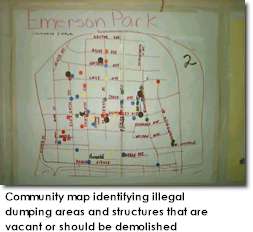
St. Louis, Illinois. New Spirit, a community organization, uses hand-drawn maps of
individual neighborhoods to compile information on scrap tire piles, abandoned housing or
vehicles, and buildings requiring demolition. Such areas tend to attract illegal dumping.
Community members use the maps to obtain funding for demolition, coordinate cleanup and
prevention efforts, and raise awareness among residents and government officials. Contact
New Spirit, (618) 874-0312.
East
St. Louis, Illinois. New Spirit, a community organization, uses hand-drawn maps of
individual neighborhoods to compile information on scrap tire piles, abandoned housing or
vehicles, and buildings requiring demolition. Such areas tend to attract illegal dumping.
Community members use the maps to obtain funding for demolition, coordinate cleanup and
prevention efforts, and raise awareness among residents and government officials. Contact
New Spirit, (618) 874-0312.
- Detroit, Michigan. Illegal dumping data from police files and court records was evaluated. Arrest records revealed that 72 percent of the dumping arrests occurred between 5:00 p.m. and 12:00 midnight, 57 percent of the dumping arrests took place on Tuesdays and Wednesdays, 66 percent of the vehicles used were pickup trucks, and 90 percent of the offenders resided within the city. The data was used to make adjustments in surveillance schedules and tactics. Court records revealed that 62 percent of offenders did not pay fines imposed and were issued lien warrants. Contact Gregory Moore, Environmental Affairs Department, (313) 237-3095.